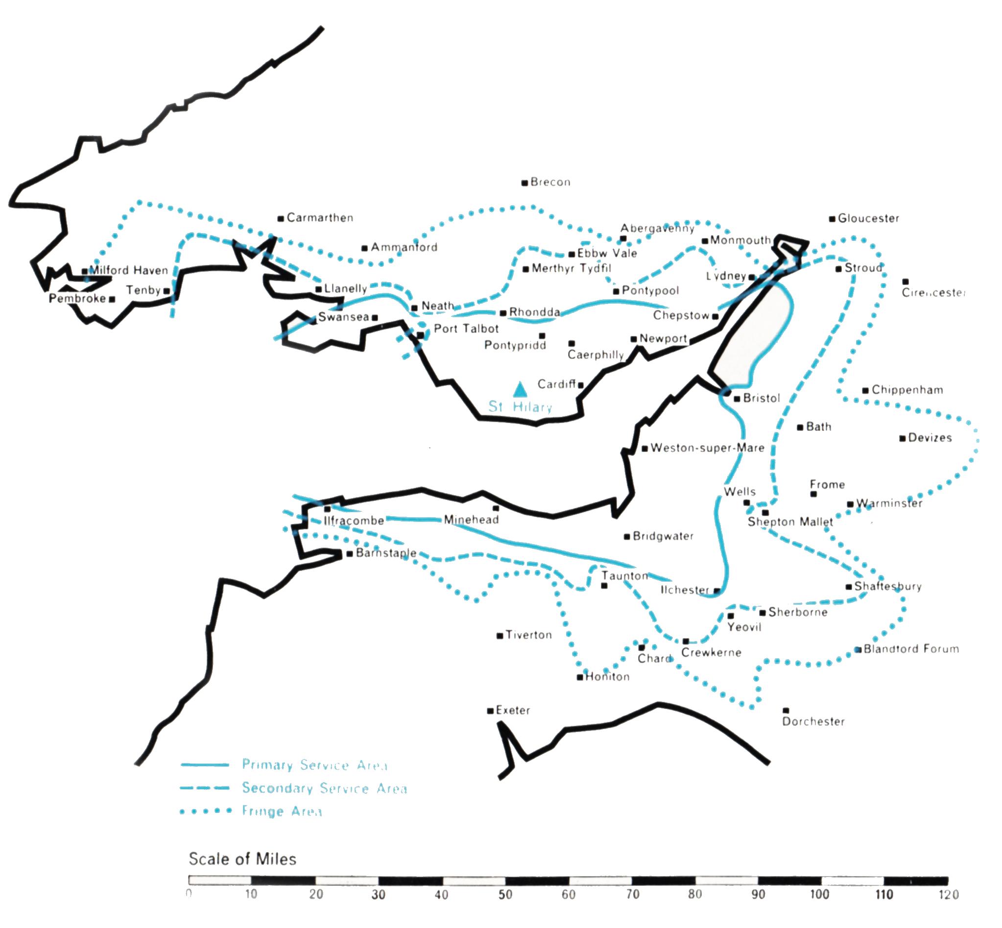
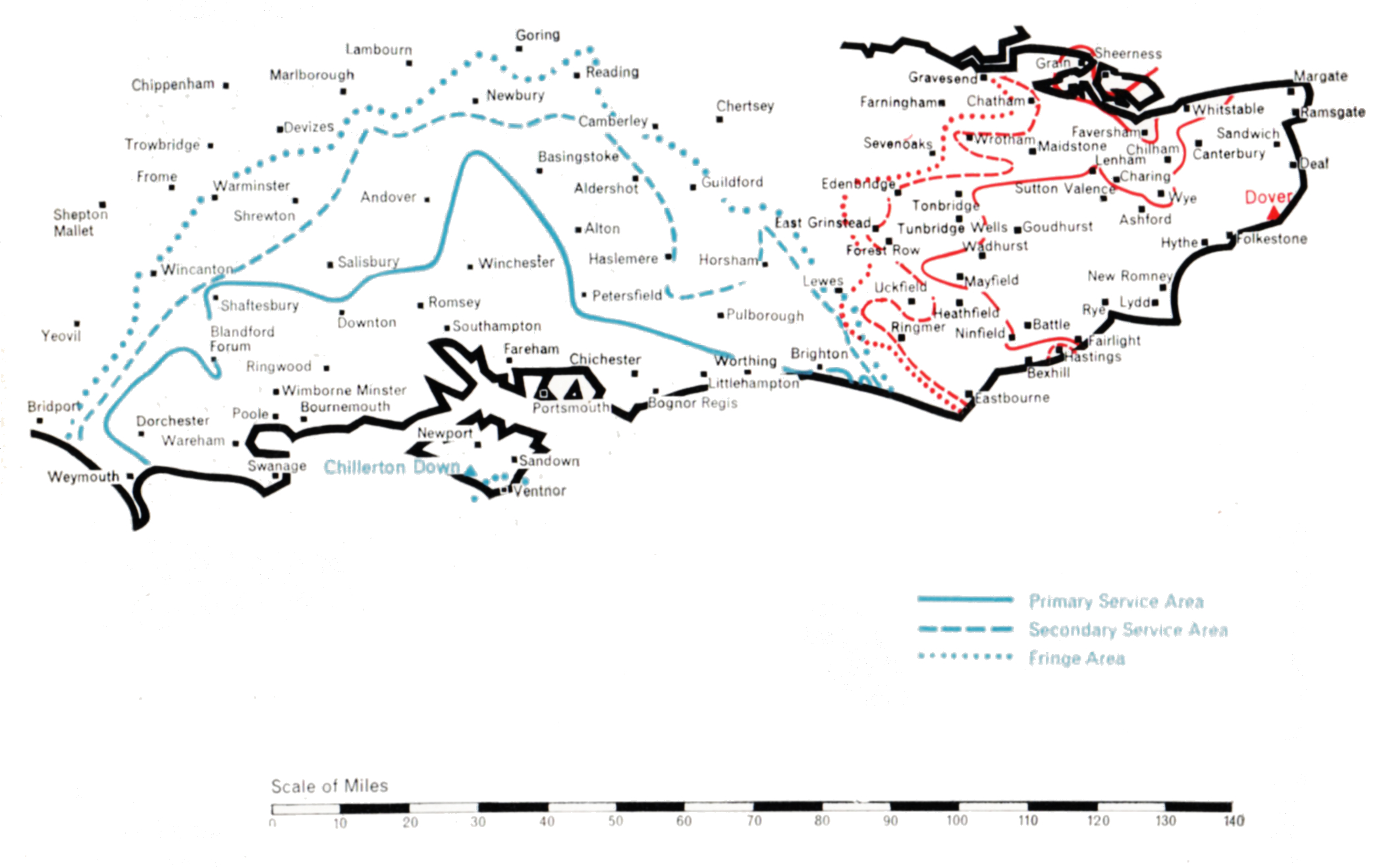
South and South-East England

Southern

  • CHILLERTON DOWN
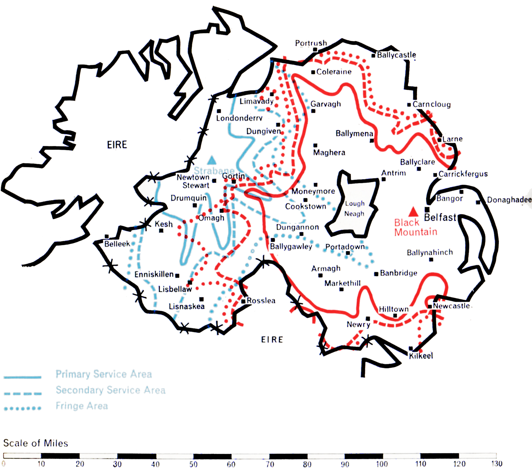
  • Population within measured contours: Primary 1.91 mn, Secondary 0.53 mn, Fringe 0.52 mn. Total 2.96 mn.
  • Channel: Band III Channel 11 (vertically polarised)
  • Vision Carrier Frequency: Actual 204.75 Mc/s
  • Sound Carrier Frequency: Actual 201.25 Mc/s
  • Effective Radiated Power: Vision 100 kw maximum. Sound 25 kw maximum.
  • Power of Transmitters: Vision (peak white) 4 kW. Sound (carrier) 1 kW
  • Heights above sea level: Site 550 ft. Mean aerial 1,250 ft.
  • Location: 1° 19′ 40″ W, 50° 38′ 55″ N.
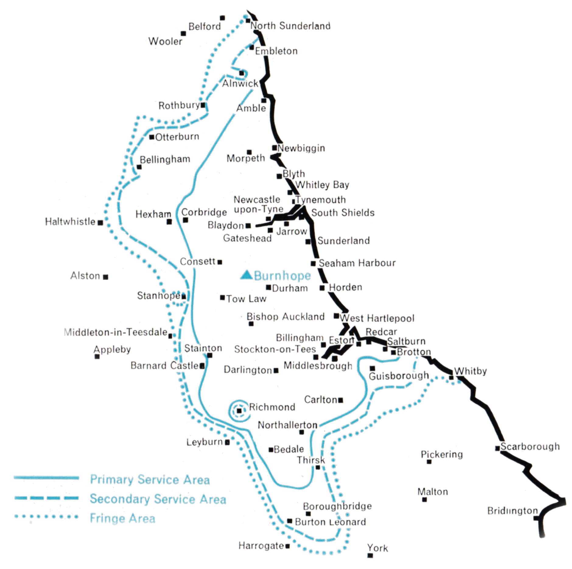
  • DOVER
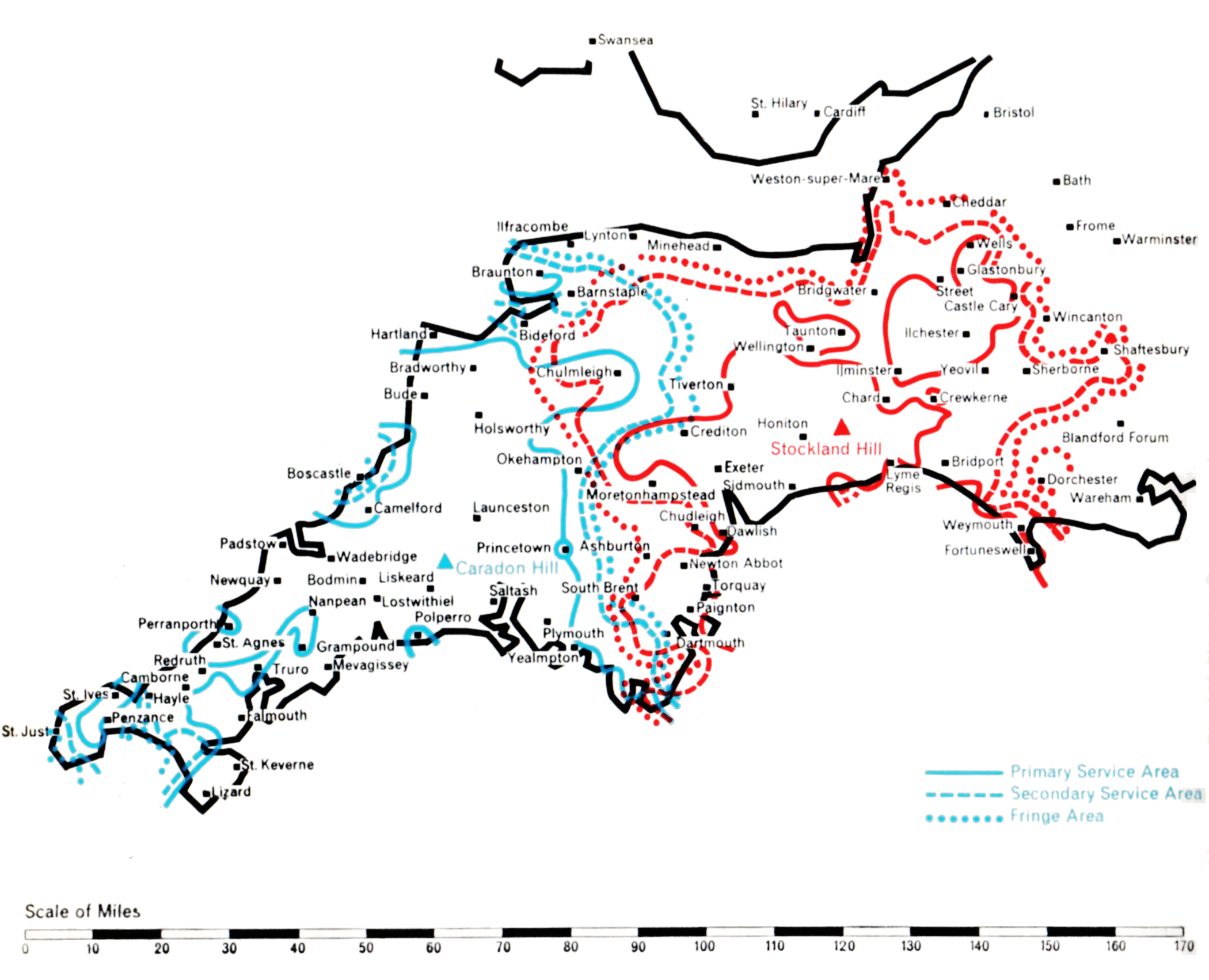
  • Population within measured contours: Primary 0.50 mn, Secondary 0.57 mn, Fringe 0.27 mn. Total 1.34 mn.
  • Channel: Band III Channel 10 (vertically polarised)
  • Vision Carrier Frequency: Nominal 199.75 Mc/s. Actual 199.7135 Mc/s
  • Sound Carrier Frequency: Nominal 196.25 Mc/s. Actual 196.1985 Mc/s
  • Effective Radiated Power: Vision 100 kw maximum. Sound 25 kw maximum.
  • Power of Transmitters: Vision (peak white) 4 kW. Sound (carrier) 1 kW
  • Heights above sea level: Site 450 ft. Mean aerial 1,175 ft.
  • Location: 1° 14′ 58″ E, 51° 6′ 40″ N.

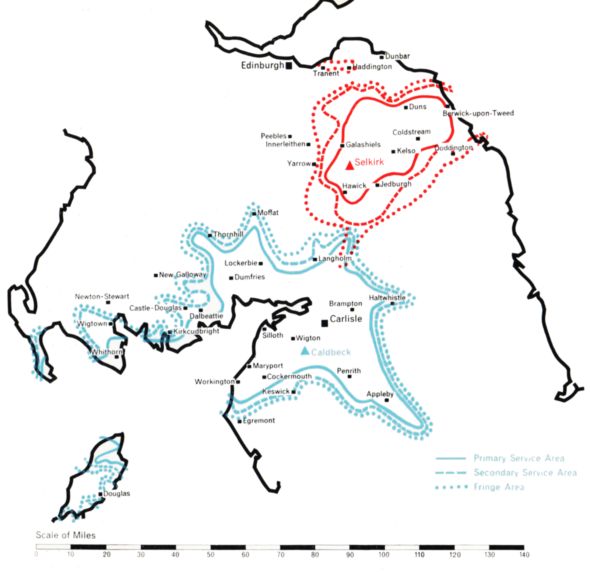
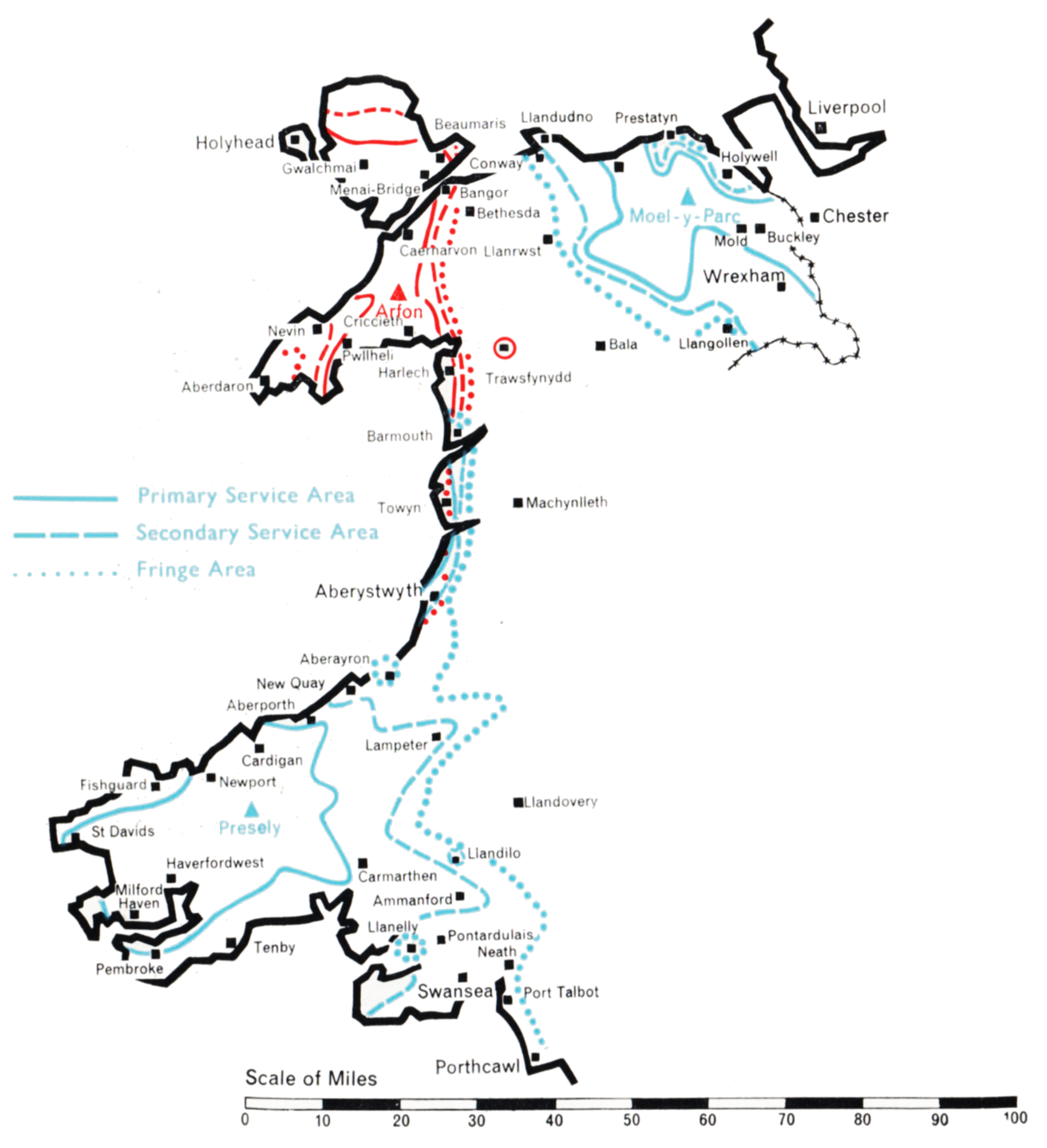
Chillerton Down (Channel 11) and Dover (Channel 10)

Company: Southern Television

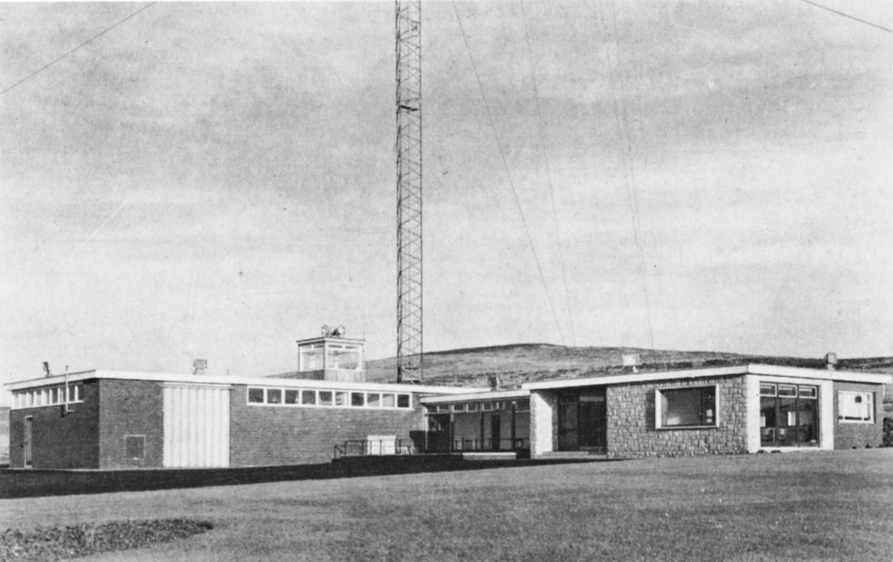
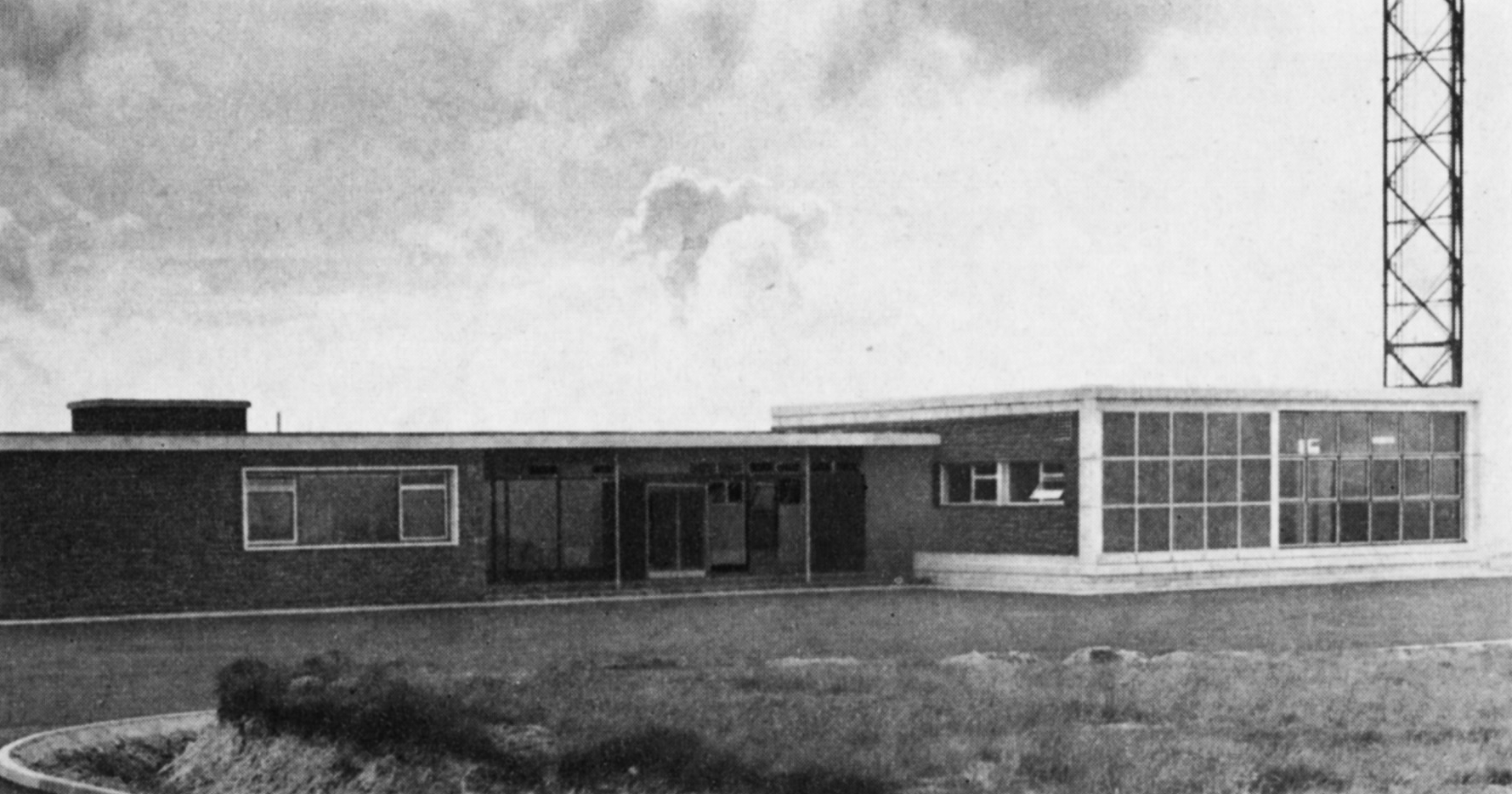
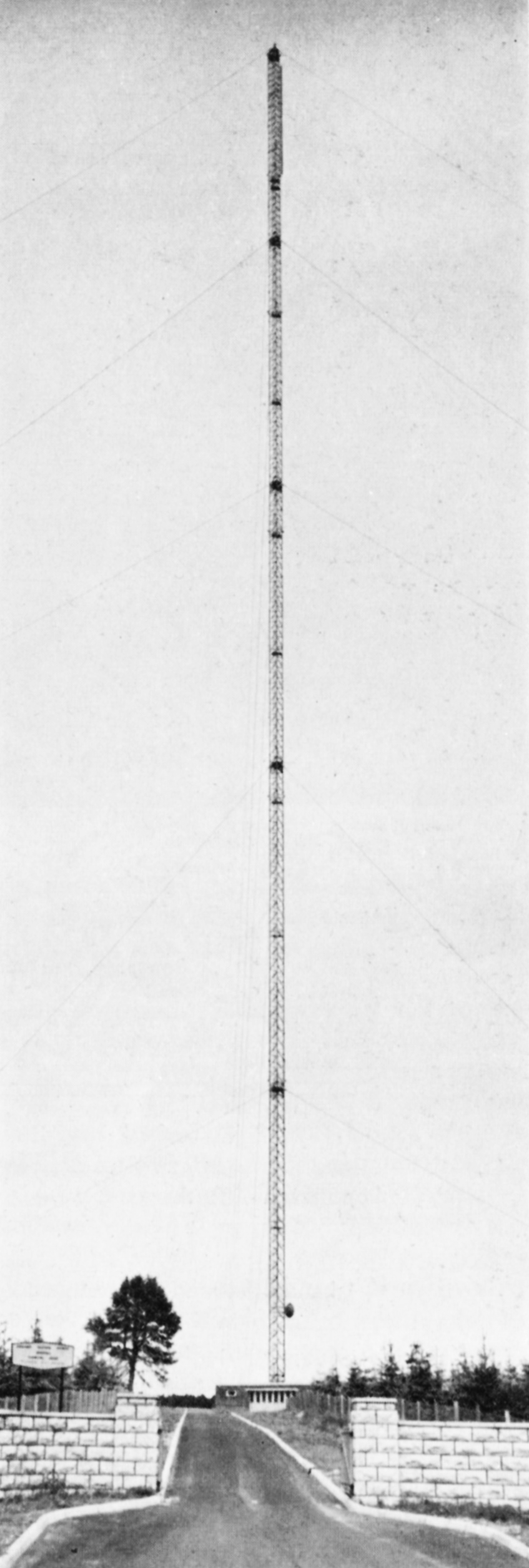
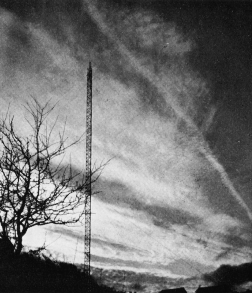
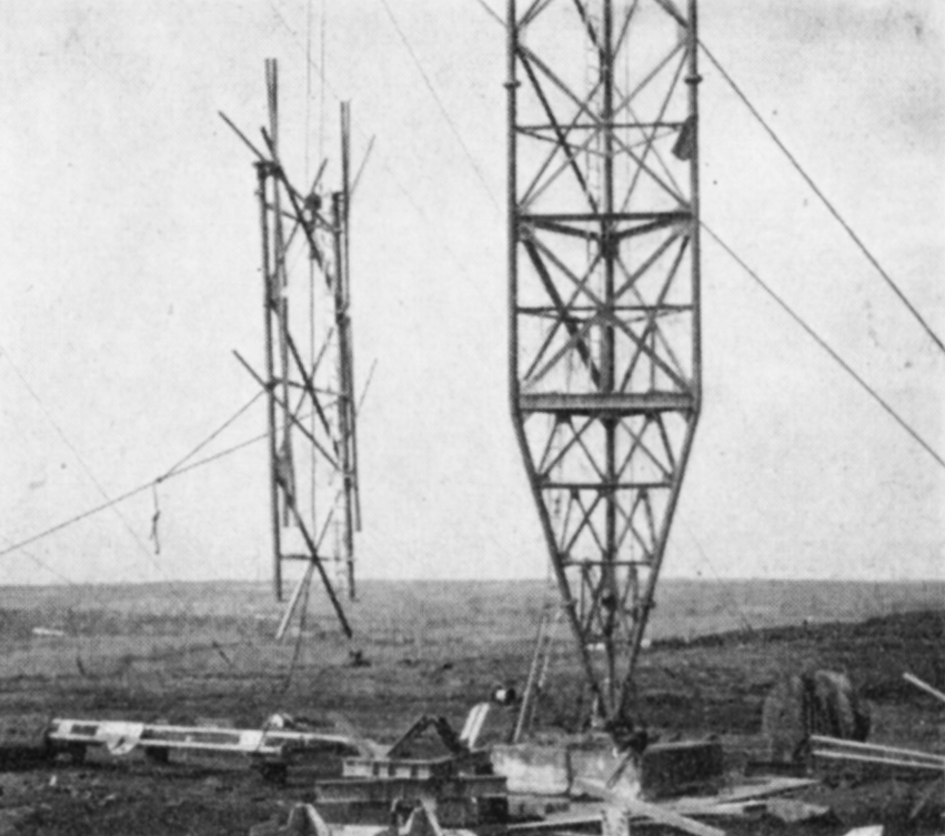
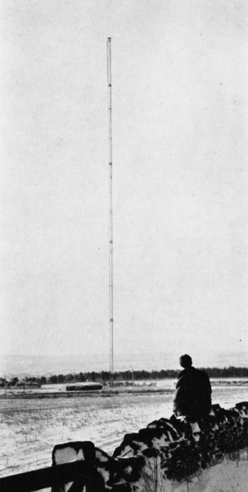
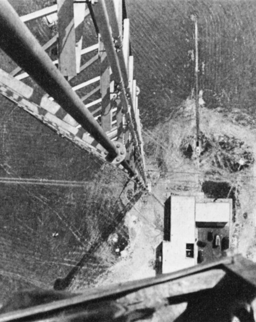
Chillerton Down was the first of the two stations built to serve the south and south-east coastal areas of Britain. It was designed to cover central southern England, the important agricultural and holiday area along the coast from Weymouth in the west to Brighton in the east, together with the great ports of Southampton and Portsmouth and, inland, the county of Hampshire and adjoining parts of Dorset and Wiltshire. A BBC Band I station existed at Rowridge, on the Isle of Wight. In conformity with the Government’s policy the Authority decided if possible to build its Band III station close to Rowridge. The site selected was on Chillerton Down, 550 ft. above sea level on the south side of the island. Opposition to a second television mast on the island was raised on grounds of amenity. However, the alternative of building at Rowridge a more massive and commanding tower to carry both the ITA and BBC television services and the BBC’s VHF sound services proved even less welcome, and the Authority’s proposal to use Chillerton Down for a slim 750 ft. mast was accepted.

Chillerton Down
Chillerton Down

The transmitting aerial has a semicircular power-radiation pattern, oriented to direct 100 kW in both directions along the coast as well as landwards, but radiating very low power across the English Channel to prevent interference with the services of Radiodiffusion-Télévision Francaise. Chillerton Down went into service on 30th August 1958 and serves the intended area well.

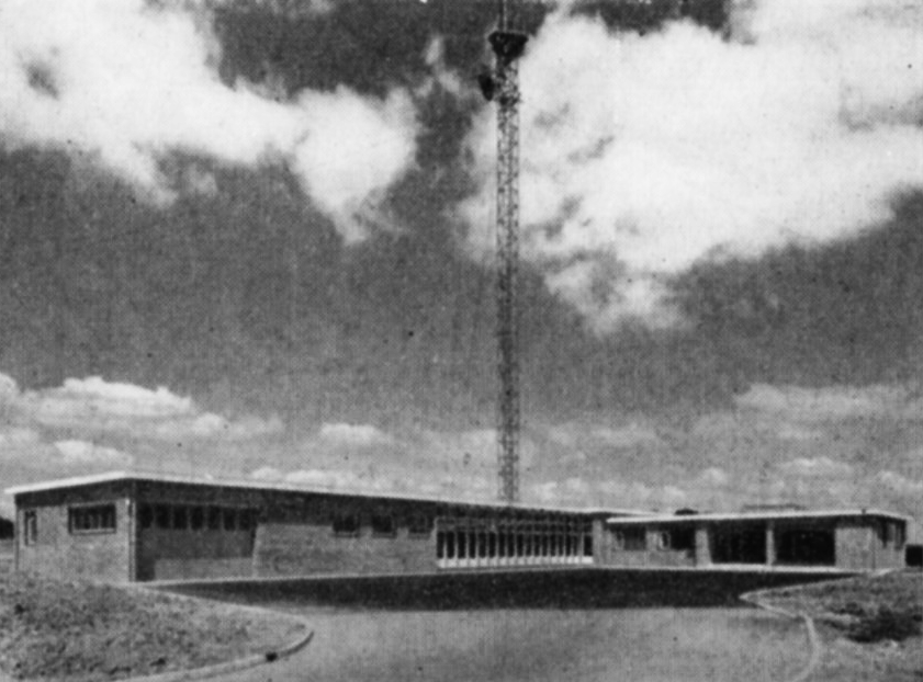
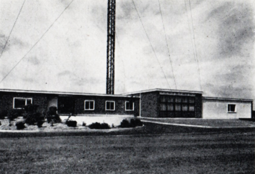
The sister station at Dover presented unusual problems. The general requirement was to serve the south-east corner of England not covered by Chillerton Down or Croydon. The site of the station was determined by the need to serve Folkestone and Dover, which lie at sea level under high cliffs. The solution was to build the station on the high cliff road linking the two towns. Church Hougham, 450 feet above sea level, was used and from a 750 ft. mast a signal could be directed into both towns. At the same time the station had to link up with the service area of Chillerton Down beyond Eastbourne, 5o miles west along the coast. 100 kW was sufficient to provide an adequate service for Eastbourne and the intermediate coastal towns, and there were no inhibiting power restrictions. Northward, to serve the towns on the Thames estuary not covered by Croydon, 10 kW to 20 kW e.r.p. was adequate. However, viewers in France had to be protected from interference to their reception of the signal from the Rouen station. Calculations showed that Dover must restrict its power to less than 1 kW over an arc of 90° towards the French Coast. It was no mean task to construct a transmitting aerial to do this, and at the same time to radiate 100 kW westward. Test transmissions were made for many weeks, during which the Authority’s engineers developed a measuring technique, using a helicopter, to check the the radiation pattern of the transmitting aerial. This difficult operation accomplished, Dover went into service on full power on 31st January 1960.

Northern Ireland

Ulster

  • BLACK MOUNTAIN
  • Population within measured contours: Primary 1.03 mn, Secondary 0.10 mn, Fringe 0.07 mn. Total 1.20 mn.
  • Channel: Band III Channel 9 (horizontally polarised)
  • Vision Carrier Frequency: Nominal 194.75 Mc/s. Actual 194.74325 Mc/s
  • Sound Carrier Frequency: Nominal 191.25 Mc/s. Actual 191.234 Mc/s
  • Effective Radiated Power: Vision 100 kw maximum. Sound 25 kw maximum.
  • Power of Transmitters: Vision (peak white) 4 kW. Sound (carrier) 1 kW
  • Heights above sea level: Site 987 ft. Mean aerial 1,687 ft.
  • Location: 6° 1′ 10″ W, 54° 35′ 10″ N.
  • STRABANE
  • Population within predicted contours: Primary 0.108 mn, Secondary 0.073 mn, Fringe 0.069 mn. Total 0.25 mn.
  • Channel: Band III Channel 8 (vertically polarised)
  • Vision Carrier Frequency: Nominal 189.75 Mc/s. Actual 189.75675 Mc/s
  • Sound Carrier Frequency: Nominal 186.25 Mc/s. Actual 186.27 Mc/s
  • Effective Radiated Power: Vision 90 kw maximum. Sound 22.5 kw maximum.
  • Power of Transmitters: Vision (peak white) 2 x 2 kW. Sound (carrier) 2 x 0.5 kW
  • Heights above sea level: Site 900 ft. Mean aerial 1,875 ft.
  • Location: 7° 23′ 10″ W, 54° 48′ 0″ N.

Black Mountain (Channel 9) and Strabane (Channel 8)

Company: Ulster Television

A large part of Northern Ireland was provided with an Independent Television service in the Autumn of 1959 by the construction of the Black Mountain station near Belfast, close to the BBC’s existing Band I station at Divis. However, West Ulster, which includes the districts of Londonderry and Enniskillen, could not be covered by this station and, clearly, at least one additional station was needed.

The Black Mountain station overlooks Belfast and is 987 ft. above sea level. A 750 ft. mast, the highest permitted by the Ministry of Transport and Civil Aviation due to the proximity of the airport, was erected. It supports a moderately-directional aerial radiating about 100 kW to both the north-west and the south-west, 7o kW to the west and 20 kW to the east. This power-radiation pattern ensures the optimum coverage of the area whilst avoiding harmful interference to the service areas of other stations using Channel 9, notably Winter Hill.

Black Mountain
Black Mountain

A study of the topography of West Ulster revealed that the unserved area could economically be covered by a single station if a high site near Strabane could be obtained. A site 900 ft. above sea level was found four miles south-east of Strabane and here a station using a 1,000 ft. mast was constructed.

It has a highly-directional aerial radiating about 9o kW in two main lobes to the north and to the south. 10 kW only is radiated to the east and west, but this suffices to cover the areas not served by the Black Mountain transmitter and, at the same time, prevents unnecessary radiation into the territory of the Irish Republic to the west.

The Black Mountain station went into service on 31st October 1959. Strabane began programme transmission during February 1963.

South-West England

Westward

  • CARADON HILL
  • Population within measured contours: Primary 0.518 mn, Secondary 0.159 mn, Fringe 0.053 mn. Total 0.73 mn.
  • Channel: Band III Channel 12 (vertically polarised)
  • Vision Carrier Frequency: Nominal 209.75 Mc/s. Actual 209.74325 Mc/s
  • Sound Carrier Frequency: Nominal 206.25 Mc/s. Actual 206.23 Mc/s
  • Effective Radiated Power: Vision 200 kw maximum. Sound 50 kw maximum.
  • Power of Transmitters: Vision (peak white) 2 x 5 kW. Sound (carrier) 2 x 1.25 kW
  • Heights above sea level: Site 1,215 ft. Mean aerial 1,925 ft.
  • Location: 4° 26′ 8″ W, 50° 30′ 39″ N.
  • STOCKLAND HILL
  • Population within measured contours: Primary 0.362 mn, Secondary 0.405 mn, Fringe 0.148 mn. Total 0.915 mn.
  • Channel: Band III Channel 9 (vertically polarised)
  • Vision Carrier Frequency: Nominal 194.75 Mc/s. Actual 194.74325 Mc/s
  • Sound Carrier Frequency: Nominal 191.25 Mc/s. Actual 191.234 Mc/s
  • Effective Radiated Power: Vision 100 kw maximum. Sound 25 kw maximum.
  • Power of Transmitters: Vision (peak white) 2 x 5 kW. Sound (carrier) 2 x 1.25 kW
  • Heights above sea level: Site 750 ft. Mean aerial 1,460 ft.
  • Location: 3° 6′ 13″ W, 50° 48′ 23″ N.

Stockland Hill (Channel 9) and Caradon Hill (Channel 12)

Company: Westward Television

Propagation studies of the best method of covering the 150 mile long wedge-shaped area of Devon and Cornwall showed that it was not practical to serve it adequately from a single Band III station centrally situated on the heights of Dartmoor, adjacent to the BBC’s station at North Hessary Tor. Government agreement was obtained to build two stations, one in Cornwall and one in South Devon, another necessary departure from the principal of co-siting with the BBC Band I station.

High sites were found at Caradon Hill, near Launceston, for Cornwall; and at Stockland Hill, near Axminster, for Devon. Transmitting aerials with highly-directional lobes were engineered to give the desired grade of service to both areas while minimising interference with other ITA and Continental stations which use the same channels. Each station needed a 750 ft. mast to minimise “shadows” in this hilly terrain.

Stockland Hill
Stockland Hill

For Caradon Hill, the requirement was to give a service to the whole of Cornwall west of Dartmoor and reaching to the extremity of England at Land’s End. A power of 200 kW e.r.p. was beamed in this direction but to avoid interference in the service area of the Dublin station the power over an arc of 40° to the north-west had to be restricted to a mere 10 kW, while to the south the power had to be restricted to 25 kW to avoid interference in the service area of the Cherbourg station.

Studies showed that in order to cover Devon while not overlapping unnecessarily with the existing service area of St. Hilary, Stockland Hill should direct its maximum power in two lobes, one north-west towards Barnstaple and the other south-west towards Dartmouth. 100 kW was the maximum permissable radiated power but restriction to 10 kW eastwards was necessary to prevent interference in the London area, which also uses Channel 9. The shape of the aerial radiation pattern thus became that of a boomerang facing westwards

A subsidiary beam of about 5o kW directed south-east towards the island of Alderney was also desirable to ensure reliable reception of the Stockland Hill signal in the island, in order to relay the mainland programmes by Post Office microwave link to the Fremont Point station in Jersey for rebroadcasting in the Channel Islands. However, the service area of the existing French station at Bourges had to be protected and the power radiated towards Alderney was restricted to 20 kW. Fortunately, in practice, this power is just sufficient for the Stockland Hill signal to be received in Alderney, with a signal to noise ratio good enough for rebroadcasting from the Fremont Point station. Both stations went into service on 29th April 1961.

The Borders

Border

  • CALDBECK
  • Population within measured contours: Primary 0.28 mn, Secondary 0.043 mn, Fringe 0.041 mn. Total 0.364 mn.
  • Channel: Band III Channel 11 (horizontally polarised)
  • Vision Carrier Frequency: Actual 204.75 Mc/s
  • Sound Carrier Frequency: Actual 201.25 Mc/s
  • Effective Radiated Power: Vision 100 kw maximum. Sound 25 kw maximum.
  • Power of Transmitters: Vision (peak white) 4 kW. Sound (carrier) 1 kW
  • Heights above sea level: Site 940 ft. Mean aerial 1,900 ft.
  • Location: 3° 5′ 21″ W, 54° 46′ 24″ N.
  • SELKIRK
  • Population within measured contours: Primary 0.071 mn, Secondary 0.026 mn, Fringe 0.019 mn. Total 0.116 mn.
  • Channel: Band III Channel 13 (vertically polarised)
  • Vision Carrier Frequency: Nominal 214.75 Mc/s. Actual 214.723 Mc/s
  • Sound Carrier Frequency: Nominal 211.25 Mc/s. Actual 211.223 Mc/s
  • Effective Radiated Power: Vision 25 kw maximum. Sound 6.25 kw maximum.
  • Power of Transmitters: Vision (peak white) 2 x 0.5 kW. Sound (carrier) 2 x 0.125 kW
  • Heights above sea level: Site 944 ft. Mean aerial 1,644 ft.
  • Location: 2° 47′ 30″ W, 55° 33′ 22″ N.

Calbeck (Channel 11) and Selkirk (Channel 13)

Company: Border Television

The Border country has two well-populated areas separated by the high sparsely-populated Cheviot Hills. That in the west extends north and south of the Solway Firth and includes the towns of Carlisle, Penrith and Dumfries. The other, in the east, embraces the Valley of the Tweed, and includes Selkirk and the coastal town of Berwick-on-Tweed.

Planning studies indicated that the best way of serving the pupulated areas was to build two separate stations, one near Carlisle and one near Selkirk. The site chosen for the first station was at Caldbeck, 940 ft. above sea level and some 10 miles west of Carlisle, in the foothills of the Cumbrian Mountains. Caldbeck lies somewhat to the south of the area to be served and a directional transmitting aerial supported on a 1,000 ft. mast was provided to radiate the maximum power of 100 kW to the northeast and the south-west, about 7o kW to the north-west across the Solway Firth, but only 20 kW to the south-east. In this direction the useful signal would naturally be blocked by mountainous country, which would not, however, prevent an interfering signal from penetrating into the service area of Mendlesham (which uses the same channel) some 200 miles distant, unless power in that direction were appropriately restricted.

Caldbeck
Caldbeck

The second station was built on Lindean Moor, 944 feet above sea level and close to Selkirk. It has a 750 ft. mast and an aerial which radiates its effective power of 25 kW mainly eastwards towards the coast. This provides a good secondary service in Berwick-on-Tweed, whilst the numerous small towns of the Tweed Valley all receive a primary service.

The Selkirk station is a satellite of Caldbeck. It obtains its programmes by direct radio pick-up from Caldbeck and rebroadcasts them on a different channel. It is the first of a number of unattended remotely-controlled satellite stations of medium to low power to be constructed by the Authority.

Caldbeck began programme service on 1st September 1961 and Selkirk on 1st December in the same year, and both well fulfil the purpose for which they were designed.

North-East Scotland

Grampian

  • DURRIS
  • Population within measured contours: Primary 0.403 mn, Secondary 0.566 mn, Fringe 0.304 mn. Total 1.273 mn.
  • Channel: Band III Channel 9 (horizontally polarised)
  • Vision Carrier Frequency: Nominal 194.75 Mc/s. Actual 194.75675 Mc/s
  • Sound Carrier Frequency: Nominal 191.25 Mc/s. Actual 191.266 Mc/s
  • Effective Radiated Power: Vision 400 kw maximum. Sound 100 kw maximum.
  • Power of Transmitters: Vision (peak white) 2 x 4 kW. Sound (carrier) 2 x 1 kW
  • Heights above sea level: Site 1,050 ft. Mean aerial 2,000 ft.
  • Location: 2° 23′ 22″ W, 57° 0′ 0″ N.
  • MOUNTEAGLE
  • Population within measured contours: Primary 0.096 mn, Secondary 0.042 mn, Fringe 0.005 mn. Total 0.143 mn.
  • Channel: Band III Channel 12 (horizontally polarised)
  • Vision Carrier Frequency: Actual 209.75 Mc/s
  • Sound Carrier Frequency: Actual 206.25 Mc/s
  • Effective Radiated Power: Vision 50 kw maximum. Sound 12.5 kw maximum.
  • Power of Transmitters: Vision (peak white) 2 kW. Sound (carrier) 0.5 kW
  • Heights above sea level: Site 730 ft. Mean aerial 1,480 ft.
  • Location: 4° 16′ 33″ W, 57° 53′ 33″ N.

Durris (Channel 9) and Mounteagle (Channel 12)

Company: Grampian Television

Two stations were necessary to cover North-East Scotland, one of medium power to serve the Inverness area and another of high power to cover Aberdeenshire and as much of Angus as possible. The main problem was to find the best site for the high-power station, which was not necessarily that of the existing BBC Band I station at Meldrum, north-west of Aberdeen.

Mounteagle
Mounteagle

For the Inverness area, a site was found at Mounteagle 730 ft. above sea level, on the Black Isle, about eight miles north of Inverness and close to the Band I station at Rosemarkie. An 800 ft. mast was used, and the maximum power of 5o kW was radiated in two directions, slightly east of north and east of south respectively. 35 kW is radiated in the direction of Lossiemouth eastwards along the Morayshire coast. Only 10 kW is radiated to the west, over the uninhabited mountainous areas of Ross and Cromarty.

Choosing the site for the high-power station to serve Aberdeen/Angus was more difficult because it was decided to try to cover the whole coastal area from Peterhead on the Moray Firth in the north to Arbroath on the Firth of Tay in the south, a distance of some 100 miles, and to include those parts of Dundee which did not receive a satisfactory service from Black Hill. A site at Durris, 1,o5o ft. above sea level, exposed, difficult of access and some 15 miles South of Aberdeen was selected. A 1,ooo ft. mast was used. Once again this choice involved a departure from the principle of adjacent siting with existing Band I stations.

The Durris station beams its power in two main lobes, each of 400 kW, one directed to the north and the other to the south-west, towards Dundee. Both stations went into service on 30th September 1961, and together cover satisfactorily the large area they were planned to serve.

West and North Wales

WWN

  • PRESELY
  • Population within measured contours: Primary 0.091 mn, Secondary 0.134 mn, Fringe 0.356 mn. Total 0.581 mn.
  • Channel: Band III Channel 8 (horizontally polarised)
  • Vision Carrier Frequency: Nominal 189.75 Mc/s. Actual 189.75675 Mc/s
  • Sound Carrier Frequency: Nominal 186.25 Mc/s. Actual 186.27 Mc/s
  • Effective Radiated Power: Vision 100 kw maximum. Sound 25 kw maximum.
  • Power of Transmitters: Vision (peak white) 5 kW. Sound (carrier) 1.25 kW
  • Heights above sea level: Site 1,100 ft. Mean aerial 1,835 ft.
  • Location: 4° 39′ 35″ W, 51° 56′ 30″ N.
  • ARFON
  • Population within measured contours: Primary 0.83 mn, Secondary 0.033 mn, Fringe 0.027 mn. Total 0.143 mn.
  • Channel: Band III Channel 10 (horizontally polarised)
  • Vision Carrier Frequency: Nominal 199.75 Mc/s. Actual 199.74725 Mc/s
  • Sound Carrier Frequency: Nominal 196.25 Mc/s. Actual 196.2605 Mc/s
  • Effective Radiated Power: Vision 10 kw maximum. Sound 2.5 kw maximum.
  • Power of Transmitters: Vision (peak white) 2 x 0.5 kW. Sound (carrier) 2 x 0.125 kW
  • Heights above sea level: Site 950 ft. Mean aerial 1,925 ft.
  • Location: 4° 16′ 10″ W, 53° 1′ 10″ N.
  • MOEL-Y-PARC
  • Population within measured contours: Primary 0.132 mn, Secondary 0.145 mn, Fringe 0.057 mn. Total 0.334 mn.
  • Channel: Band III Channel 11 (vertically polarised)
  • Vision Carrier Frequency: Nominal 204.75 Mc/s. Actual 204.75675 Mc/s
  • Sound Carrier Frequency: Nominal 201.25 Mc/s. Actual 201.27 Mc/s
  • Effective Radiated Power: Vision 25 kw maximum. Sound 6.25 kw maximum.
  • Power of Transmitters: Vision (peak white) 2 x 0.5 kW. Sound (carrier) 2 x 0.125 kW
  • Heights above sea level: Site 1,115 ft. Mean aerial 1,815 ft.
  • Location: 3° 18′ 48″ W, 53° 13′ 15″ N.

Presely (Channel 8), Arfon (Channel 10), and Moel-y-Parc (Channel 11)

Company: Wales (West and North) Television

This group of stations was planned to bring Independent Television programmes to the Welsh-speaking populations of West and North Wales, including the area bordering on Cheshire which contains the towns of Denbigh, Mold and Wrexham. The populated areas are mainly along the west coast from Pembroke to Anglesey, and on the north coast from Conway and Llandudno to Prestatyn.

The technical problem was unusually complicated. It has been solved by the establishment of three stations, one on the Prescelly mountains in Pembrokeshire, one on the Lleyn Peninsula, and one on the Clwydian Range of mountains in the Flint-Denbigh area. This plan departed considerably from an earlier one based on sites previously selected for BBC Band I stations.

ill-preselli
Presely

A site for the Presely station was found at Foel Drych 1,100 ft. above sea level, where a 770 ft. mast was sufficient to give the required coverage, although the radiation pattern of the transmitting aerial had to be extremely complicated. A narrow beam radiating 8o kW to the north was required to ensure a reliable programme link to the Arfon relay station. A beam of 100 kW to the south-east, in the direction of Carmarthen and Llanelly, was necessary to ensure that the service area of Presely joined that of St. Hilary; and a broad lobe of 5o kW to the south-west was needed to serve Pembrokeshire. At the same time severe power restrictions had to be incorporated in several directions to avoid co-channel interference in the service areas of the ITA’s transmitters at Strabane, Burnhope and Lichfield, the Kilkenny station of the Irish Republic, and the French stations serving the coast of Brittany. Intensive development was necessary to construct an aerial with this complicated radiation pattern.

The unattended Arfon station, which rebroadcasts the Presely transmissions, is at Bryn-ychain, ten miles south of Caernarvon, 950 ft. above sea level. A 1,ooo ft. mast was used to “see” over the mountains of Portmadoc to the coast of Cardigan Bay from Harlech to Barmouth, and to ensure the link with the service area of Presely. A directional aerial was again necessary. 10 kW is radiated to the north and south-west, 5 kW to the east and south-east, and 2.5 kW to the west.

The third station is at Moel-y-Parc, a peak in the Clwydian Range 1,100 ft. above sea level, and serves the North Wales area. A 750 ft. mast was found adequate to reach the coastal resins from Conway to Prestatyn, which are shielded by mountains close to the coast. The radiation pattern of the transmitting aerial is approximately semicircular, 25 kW being radiated from south-east to north-west with reduced power to the north and east. This was necessary to cover the Welsh areas but to avoid overlap with English areas already served by Winter Hill. Moel-y-Parc rebroadcasts the transmissions from the Arfon station, conveyed to it by an off the air pick-up at Nebo, in Anglesey, followed by a microwave link.

All three stations for the west and north of the Principality were in programme service by early 1963.

The Midlands

ATVABC

  • Population within measured contours: Primary 5.01 mn, Secondary 1.51 mn, Fringe 0.93 mn. Total 7.45 mn.
  • Channel: Band III Channel 8 (vertically polarised)
  • Vision Carrier Frequency: Actual 189.75 Mc/s
  • Sound Carrier Frequency: Actual 186.25 Mc/s
  • Effective Radiated Power: Vision 400 kw maximum. Sound 100 kw maximum.
  • Power of Transmitters: Vision (peak white) 20 kW. Sound (carrier) 5 kW
  • Heights above sea level: Site 500 ft. Mean aerial 1,450 ft.
  • Location: 1° 45′ 40″ W, 52° 36′ 30″ N.

Lichfield (Channel 8)

Companies: Associated TeleVision (weekdays), A.B.C. Television (weekends)

Geographically, the siting of a station to serve the industrial Midlands proved fairly straightforward, because the service area of the BBC’s Band I station at Sutton Coldfield corresponded closely with that which the Authority also wished to achieve. High open ground in the area is scarce and, with reason, carefully protected. It was not therefore easy to find an acceptable site. A piece of land 500 ft. above sea level, about four miles north-east of the BBC station, was eventually secured. It lies near the Watling Street in the rural district of Lichfield, from which the station derives its name.

Initially, an available design of 450 ft. self-supporting steel tower was erected, carrying an omnidirectional aerial similar to the one used at Croydon but of twice the aperture. This enabled a service to be provided quickly. The station went into programme service on 17th February 1956 with a single 5 kW transmitter, giving an effective radiated power of 6o kW. A few months later the power was raised to 120 kW by paralleling two 5 kW sets into the split aerial. In November of the same year, after the main 20 kW transmitter had been installed, the power was raised to 200 kW e.r.p. This gave a population coverage of nearly 6.5 million within the o.25 mV/m contouur. From the start it was recognised that, because of the relatively low site, greater and more uniform coverage could be obtained with a higher mast and an aerial system with directional characteristics. Sufficient land was therefore acquired to permit this to be done later.

ill-lichfieldEarly in 1961 it became possible to start the construction of a 1,000 ft. mast and an improved aerial. Both these were brought into service in July of the same year, thus allowing the original tower to be dismantled and re-erected for use at the Fremont Point station in the Channel Islands. The new aerial enabled the power radiated south towards Gloucester to be increased to 400 kW.

Towards East Anglia, however, the power had to be reduced to 100 kW to prevent harmful interference to viewers of the Netherlands Television Service on the Dutch coast. For this reason, the service to Midlands viewers living east of the station remained substantially unchanged. Over a semi-circle towards the north the radiated power was maintained at 200 kW. This was sufficient, with the higher aerial, to close the gaps between the service areas of Lichfield and the Winter Hill and Emley Moor stations. The effect of the new mast and aerial was a general all-round improvement in reception, both within the old service area and beyond. The predicted coverage is shown in the map opposite. The measured coverage has recently been completed and includes a population of 8.85 million within the 0.25 mV/m contour.

Central Scotland

Scottish

  • Population within measured contours: Primary 3.23 mn, Secondary 0.54 mn, Fringe 0.21 mn. Total 3.98 mn.
  • Channel: Band III Channel 10 (vertically polarised)
  • Vision Carrier Frequency: Nominal 199.75 Mc/s. Actual 199.7305 Mc/s
  • Sound Carrier Frequency: Nominal 196.25 Mc/s. Actual 196.2395 Mc/s
  • Effective Radiated Power: Vision 475 kw maximum. Sound 120 kw maximum.
  • Power of Transmitters: Vision (peak white) 2 x 10 kW. Sound (carrier) 2 x 2.5 kW
  • Heights above sea level: Site 900 ft. Mean aerial 1,850 ft.
  • Location: 3° 52′ 25″ W, 55° 51′ 45″ N.

Black Hill (Channel 10)

Company: Scottish Television

The construction of this station, on a site 900 ft. above sea level and midway between Glasgow and Edinburgh, began in the late summer of 1956. The station was designed to serve the central lowlands of Scotland, covering a population of nearly four millions within the o.25 mV/m contour.

The selection of the site was straightforward, but there was difficulty in obtaining the land.

A study of the topography within the required service area of this station established the need for a 750 ft. mast and it was evident that the best possible coverage could be obtained only by using a directional aerial system. It was important that, if possible, both Dundee in the north-east and the towns on the Ayrshire coast in the west should be included in the service area. Little benefit, however, would result from radiating high power into the hilly north-westerly or south-easterly directions. It thus appeared that an aerial having an elliptical power distribution pattern with its major axis aligned to the north-east and south-west would provide the best result. However, an international limitation on power in certain directions made it necessary to compromise and to design an aerial whose radiation pattern can best be described as “boot”-shaped, the “heel” (250 kw) directed towards the south-west and the “sole” (475 kW) directed to the north-east. A power of about 150 kW was adequate for the northwest and south-west directions.

ill-black hillA novel 16-stack vertically-polarised directional aerial system was developed, possessing many useful features, which attempted to approximate to the optimum power-radiation pattern. The aerial was located centrally within the mast structure to radiate through the opening of the lattice steel formation of the mast, mainly to reduce the wind loading and icing on the exposed site.

Unfortunately, complex anomalies in the behaviour of this aerial caused its performance to deviate from the prediction. The desired power in the various directions was not completely achieved, while the radiation in the south-west sector in the direction of Ayr was predominantly horizontally instead of vertically polarised. The result was a marginal shift in the potential service area of the station. These anomalies had to be accepted for the time being, and the station came into service on 31st August 1957.

In 1959 it was decided to replace the “inside the mast” aerial by one of more conventional form, with the radiators mounted outside the mast. In order to ensure continuity of service, it was also decided to erect the replacement aerial on a new 1,ooo ft. mast near the original mast.

The difficult task of constructing the new mast close to the old began in August 1960. It was brought into use together with the new aerial on 10th July 1961. The 750 ft. mast was dismantled and has been used at the Selkirk station in the Borders. The performance of the new aerial at Black Hill is satisfactory and has resulted in an enlargement of the service area and in improvements to reception generally.

South Wales and West of England

TWW

  • Population within measured contours: Primary 1.517 mn, Secondary 1.0 mn, Fringe 0.77 mn. Total 3.287 mn.
  • Channel: Band III Channel 10 (vertically polarised)
  • Vision Carrier Frequency: Nominal 199.75 Mc/s. Actual 199.7305 Mc/s
  • Sound Carrier Frequency: Nominal 196.25 Mc/s. Actual 196.2395 Mc/s
  • Effective Radiated Power: Vision 200 kw maximum. Sound 50 kw maximum.
  • Power of Transmitters: Vision (peak white) 20 kW. Sound (carrier) 5 kW
  • Heights above sea level: Site 400 ft. Mean aerial 1,100 ft.
  • Location: 3° 24′ 15″ W, 51° 27′ 25″ N.

St. Hilary (Channel 10)

Company: T.W.W.

This station brings the Independent Television programmes to the Welsh and English populations adjacent to the Severn Estuary and the Bristol Channel. With the limited number of Band III channels available to the Authority, each one had to be used to serve the maximum possible geographical area. In May 1955, studies were begun to determine which of a number of approaches to the problem of covering South Wales, North Somerset and North Devon was the best. The coverage potential of sites to the south of the Estuary in the Mendips and the Quantocks, as well as on the north shore in various parts of South Wales, was investigated.

A site was selected at St. Hilary Down, on the Welsh side of the estuary, between Cardiff and Swansea, and 400 ft. above sea level. This gave the maximum potential population coverage of the densely populated areas of industrial South Wales and Monmouthshire, and was adjacent to the BBC Band I station at Wenvoe a few miles to the east, serving broadly the same geographical area.

ill-st hilaryThe mast height at St. Hilary is 750 ft. The Authority would have preferred 1,000 ft., but air navigation considerations precluded this. Even so, approval for the site had to be withheld by the Glamorgan County Council pending a public enquiry, held in March 1957, to resolve the objections to the mast lodged by the airline companies operating from the nearby Rhoose Airport. The effective radiated power is 200 kW omni-directional, because directional characteristics would have been of little avail in improving the service for the many valleys of South Wales, which radiate northwards like spokes of a wheel from the “hubs” of Cardiff and Newport.

A major redesign of the aerial system had to be undertaken, because the intended “inside the mast” type of aerial, the prototype of which had just been tested at the Black Hill station in Scotland, had been found to be deficient.

The station was opened for programmes, with an aerial of more conventional design, on 14th January 1958. It has given the high grade of service predicted, but the fundamental limitations of Band III transmission and reception in mountainous terrain when compared with Band I led to some public disappointment about the comparative grades of service in some shielded locations in the deep valleys of South Wales and also in low-lying parts of the cities of Bristol and Bath. The use of well designed receiving aerials and of more sensitive “fringe area” receivers has overcome, in part, the low signal strength and the “ghost” images experienced in such localities.

North-East England

TTT

  • Population within measured contours: Primary 2.48 mn, Secondary 0.19 mn, Fringe 0.05 mn. Total 2.72 mn.
  • Channel: Band III Channel 8 (horizontally polarised)
  • Vision Carrier Frequency: Nominal 189.75 Mc/s. Actual 189.75675 Mc/s
  • Sound Carrier Frequency: Nominal 186.25 Mc/s. Actual 186.27 Mc/s
  • Effective Radiated Power: Vision 100 kw maximum. Sound 25 kw maximum.
  • Power of Transmitters: Vision (peak white) 4 kW. Sound (carrier) 1 kW
  • Heights above sea level: Site 800 ft. Mean aerial 1,500 ft.
  • Location: 1° 42′ 50″ W, 54° 49′ 25″ N.

Burnhope (Channel 8)

Company: Tyne Tees Television

The important highly-populated industrial and agricultural area of North-East England, between the eastern slopes of the Pennine Chain and the sea, lies beyond the range of the Emley Moor transmitter in Yorkshire. Another station was therefore needed to provide an Independent Television service for this area.

ill-burnhopeA high site was found at Burnhope, about ten miles south-west of Newcastle-upon-Tyne, the major city in the area. It was within a few miles of the existing Band I station at Pontop Pike. Finding a site presented no special difficulty except the importance of avoiding land liable to mining subsidence, which abounds in this locality. This was responsible for some delay while the records were searched and test bores made.

A mast 750 feet in height was needed to prevent “shadowing” in the rather hilly country and the maximum power of 100 kW which could be permitted on this channel was radiated in both the northerly and the southerly directions, so as to extend the service as far as possible. To the west the service is naturally blocked by the high barrier of the Pennine Chain and to the east its usefulness is limited by the North Sea. The power radiated in these directions was therefore limited to 20 kW and 7o kW respectively, no higher power being necessary. Again a special aerial had to be developed to give the required directional effect.

The station went into programme service on 15th January 1959 and has fulfilled its predicted performance.