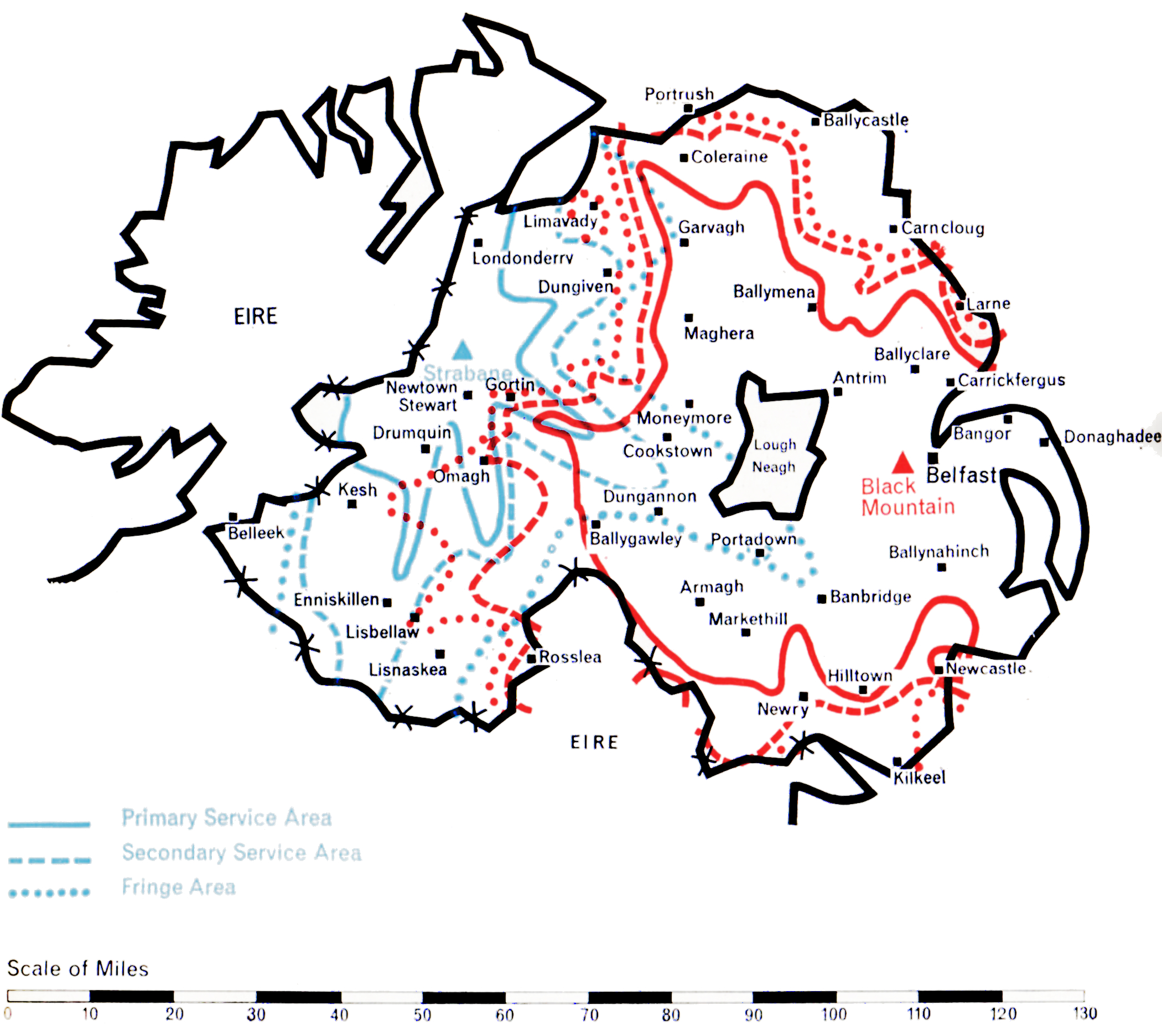
Northern Ireland

Ulster

  • BLACK MOUNTAIN
  • Population within measured contours: Primary 1.03 mn, Secondary 0.10 mn, Fringe 0.07 mn. Total 1.20 mn.
  • Channel: Band III Channel 9 (horizontally polarised)
  • Vision Carrier Frequency: Nominal 194.75 Mc/s. Actual 194.74325 Mc/s
  • Sound Carrier Frequency: Nominal 191.25 Mc/s. Actual 191.234 Mc/s
  • Effective Radiated Power: Vision 100 kw maximum. Sound 25 kw maximum.
  • Power of Transmitters: Vision (peak white) 4 kW. Sound (carrier) 1 kW
  • Heights above sea level: Site 987 ft. Mean aerial 1,687 ft.
  • Location: 6° 1′ 10″ W, 54° 35′ 10″ N.
  • STRABANE
  • Population within predicted contours: Primary 0.108 mn, Secondary 0.073 mn, Fringe 0.069 mn. Total 0.25 mn.
  • Channel: Band III Channel 8 (vertically polarised)
  • Vision Carrier Frequency: Nominal 189.75 Mc/s. Actual 189.75675 Mc/s
  • Sound Carrier Frequency: Nominal 186.25 Mc/s. Actual 186.27 Mc/s
  • Effective Radiated Power: Vision 90 kw maximum. Sound 22.5 kw maximum.
  • Power of Transmitters: Vision (peak white) 2 x 2 kW. Sound (carrier) 2 x 0.5 kW
  • Heights above sea level: Site 900 ft. Mean aerial 1,875 ft.
  • Location: 7° 23′ 10″ W, 54° 48′ 0″ N.

Black Mountain (Channel 9) and Strabane (Channel 8)

Company: Ulster Television

A large part of Northern Ireland was provided with an Independent Television service in the Autumn of 1959 by the construction of the Black Mountain station near Belfast, close to the BBC’s existing Band I station at Divis. However, West Ulster, which includes the districts of Londonderry and Enniskillen, could not be covered by this station and, clearly, at least one additional station was needed.

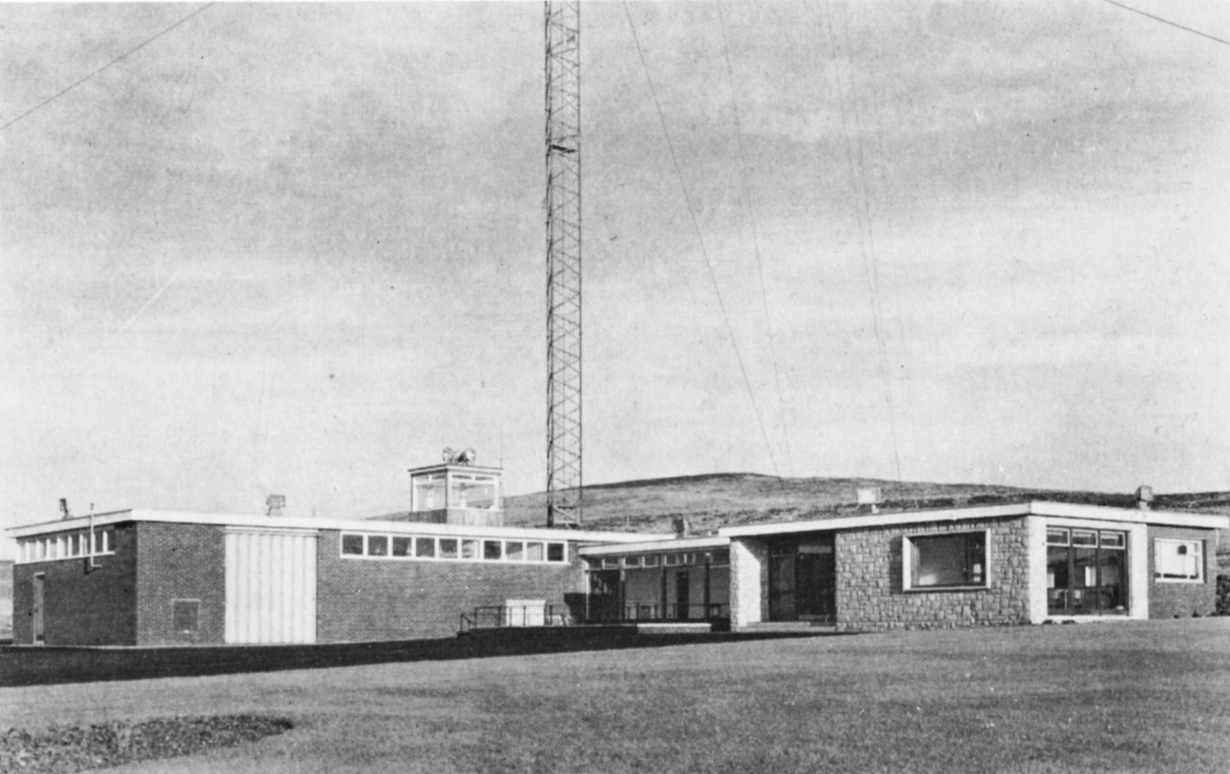
The Black Mountain station overlooks Belfast and is 987 ft. above sea level. A 750 ft. mast, the highest permitted by the Ministry of Transport and Civil Aviation due to the proximity of the airport, was erected. It supports a moderately-directional aerial radiating about 100 kW to both the north-west and the south-west, 7o kW to the west and 20 kW to the east. This power-radiation pattern ensures the optimum coverage of the area whilst avoiding harmful interference to the service areas of other stations using Channel 9, notably Winter Hill.

Black Mountain
Black Mountain

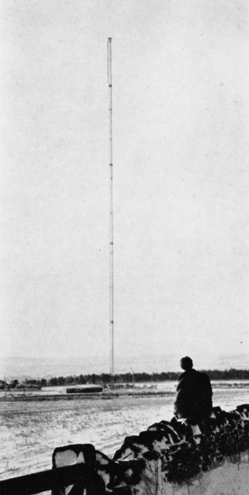
A study of the topography of West Ulster revealed that the unserved area could economically be covered by a single station if a high site near Strabane could be obtained. A site 900 ft. above sea level was found four miles south-east of Strabane and here a station using a 1,000 ft. mast was constructed.

It has a highly-directional aerial radiating about 9o kW in two main lobes to the north and to the south. 10 kW only is radiated to the east and west, but this suffices to cover the areas not served by the Black Mountain transmitter and, at the same time, prevents unnecessary radiation into the territory of the Irish Republic to the west.

The Black Mountain station went into service on 31st October 1959. Strabane began programme transmission during February 1963.

West and North Wales

WWN

  • PRESELY
  • Population within measured contours: Primary 0.091 mn, Secondary 0.134 mn, Fringe 0.356 mn. Total 0.581 mn.
  • Channel: Band III Channel 8 (horizontally polarised)
  • Vision Carrier Frequency: Nominal 189.75 Mc/s. Actual 189.75675 Mc/s
  • Sound Carrier Frequency: Nominal 186.25 Mc/s. Actual 186.27 Mc/s
  • Effective Radiated Power: Vision 100 kw maximum. Sound 25 kw maximum.
  • Power of Transmitters: Vision (peak white) 5 kW. Sound (carrier) 1.25 kW
  • Heights above sea level: Site 1,100 ft. Mean aerial 1,835 ft.
  • Location: 4° 39′ 35″ W, 51° 56′ 30″ N.
  • ARFON
  • Population within measured contours: Primary 0.83 mn, Secondary 0.033 mn, Fringe 0.027 mn. Total 0.143 mn.
  • Channel: Band III Channel 10 (horizontally polarised)
  • Vision Carrier Frequency: Nominal 199.75 Mc/s. Actual 199.74725 Mc/s
  • Sound Carrier Frequency: Nominal 196.25 Mc/s. Actual 196.2605 Mc/s
  • Effective Radiated Power: Vision 10 kw maximum. Sound 2.5 kw maximum.
  • Power of Transmitters: Vision (peak white) 2 x 0.5 kW. Sound (carrier) 2 x 0.125 kW
  • Heights above sea level: Site 950 ft. Mean aerial 1,925 ft.
  • Location: 4° 16′ 10″ W, 53° 1′ 10″ N.
  • MOEL-Y-PARC
  • Population within measured contours: Primary 0.132 mn, Secondary 0.145 mn, Fringe 0.057 mn. Total 0.334 mn.
  • Channel: Band III Channel 11 (vertically polarised)
  • Vision Carrier Frequency: Nominal 204.75 Mc/s. Actual 204.75675 Mc/s
  • Sound Carrier Frequency: Nominal 201.25 Mc/s. Actual 201.27 Mc/s
  • Effective Radiated Power: Vision 25 kw maximum. Sound 6.25 kw maximum.
  • Power of Transmitters: Vision (peak white) 2 x 0.5 kW. Sound (carrier) 2 x 0.125 kW
  • Heights above sea level: Site 1,115 ft. Mean aerial 1,815 ft.
  • Location: 3° 18′ 48″ W, 53° 13′ 15″ N.

Presely (Channel 8), Arfon (Channel 10), and Moel-y-Parc (Channel 11)

Company: Wales (West and North) Television

This group of stations was planned to bring Independent Television programmes to the Welsh-speaking populations of West and North Wales, including the area bordering on Cheshire which contains the towns of Denbigh, Mold and Wrexham. The populated areas are mainly along the west coast from Pembroke to Anglesey, and on the north coast from Conway and Llandudno to Prestatyn.

The technical problem was unusually complicated. It has been solved by the establishment of three stations, one on the Prescelly mountains in Pembrokeshire, one on the Lleyn Peninsula, and one on the Clwydian Range of mountains in the Flint-Denbigh area. This plan departed considerably from an earlier one based on sites previously selected for BBC Band I stations.

ill-preselli
Presely

A site for the Presely station was found at Foel Drych 1,100 ft. above sea level, where a 770 ft. mast was sufficient to give the required coverage, although the radiation pattern of the transmitting aerial had to be extremely complicated. A narrow beam radiating 8o kW to the north was required to ensure a reliable programme link to the Arfon relay station. A beam of 100 kW to the south-east, in the direction of Carmarthen and Llanelly, was necessary to ensure that the service area of Presely joined that of St. Hilary; and a broad lobe of 5o kW to the south-west was needed to serve Pembrokeshire. At the same time severe power restrictions had to be incorporated in several directions to avoid co-channel interference in the service areas of the ITA’s transmitters at Strabane, Burnhope and Lichfield, the Kilkenny station of the Irish Republic, and the French stations serving the coast of Brittany. Intensive development was necessary to construct an aerial with this complicated radiation pattern.

The unattended Arfon station, which rebroadcasts the Presely transmissions, is at Bryn-ychain, ten miles south of Caernarvon, 950 ft. above sea level. A 1,ooo ft. mast was used to “see” over the mountains of Portmadoc to the coast of Cardigan Bay from Harlech to Barmouth, and to ensure the link with the service area of Presely. A directional aerial was again necessary. 10 kW is radiated to the north and south-west, 5 kW to the east and south-east, and 2.5 kW to the west.

The third station is at Moel-y-Parc, a peak in the Clwydian Range 1,100 ft. above sea level, and serves the North Wales area. A 750 ft. mast was found adequate to reach the coastal resins from Conway to Prestatyn, which are shielded by mountains close to the coast. The radiation pattern of the transmitting aerial is approximately semicircular, 25 kW being radiated from south-east to north-west with reduced power to the north and east. This was necessary to cover the Welsh areas but to avoid overlap with English areas already served by Winter Hill. Moel-y-Parc rebroadcasts the transmissions from the Arfon station, conveyed to it by an off the air pick-up at Nebo, in Anglesey, followed by a microwave link.

All three stations for the west and north of the Principality were in programme service by early 1963.

The Midlands

ATVABC

  • Population within measured contours: Primary 5.01 mn, Secondary 1.51 mn, Fringe 0.93 mn. Total 7.45 mn.
  • Channel: Band III Channel 8 (vertically polarised)
  • Vision Carrier Frequency: Actual 189.75 Mc/s
  • Sound Carrier Frequency: Actual 186.25 Mc/s
  • Effective Radiated Power: Vision 400 kw maximum. Sound 100 kw maximum.
  • Power of Transmitters: Vision (peak white) 20 kW. Sound (carrier) 5 kW
  • Heights above sea level: Site 500 ft. Mean aerial 1,450 ft.
  • Location: 1° 45′ 40″ W, 52° 36′ 30″ N.

Lichfield (Channel 8)

Companies: Associated TeleVision (weekdays), A.B.C. Television (weekends)

Geographically, the siting of a station to serve the industrial Midlands proved fairly straightforward, because the service area of the BBC’s Band I station at Sutton Coldfield corresponded closely with that which the Authority also wished to achieve. High open ground in the area is scarce and, with reason, carefully protected. It was not therefore easy to find an acceptable site. A piece of land 500 ft. above sea level, about four miles north-east of the BBC station, was eventually secured. It lies near the Watling Street in the rural district of Lichfield, from which the station derives its name.

Initially, an available design of 450 ft. self-supporting steel tower was erected, carrying an omnidirectional aerial similar to the one used at Croydon but of twice the aperture. This enabled a service to be provided quickly. The station went into programme service on 17th February 1956 with a single 5 kW transmitter, giving an effective radiated power of 6o kW. A few months later the power was raised to 120 kW by paralleling two 5 kW sets into the split aerial. In November of the same year, after the main 20 kW transmitter had been installed, the power was raised to 200 kW e.r.p. This gave a population coverage of nearly 6.5 million within the o.25 mV/m contouur. From the start it was recognised that, because of the relatively low site, greater and more uniform coverage could be obtained with a higher mast and an aerial system with directional characteristics. Sufficient land was therefore acquired to permit this to be done later.

ill-lichfieldEarly in 1961 it became possible to start the construction of a 1,000 ft. mast and an improved aerial. Both these were brought into service in July of the same year, thus allowing the original tower to be dismantled and re-erected for use at the Fremont Point station in the Channel Islands. The new aerial enabled the power radiated south towards Gloucester to be increased to 400 kW.

Towards East Anglia, however, the power had to be reduced to 100 kW to prevent harmful interference to viewers of the Netherlands Television Service on the Dutch coast. For this reason, the service to Midlands viewers living east of the station remained substantially unchanged. Over a semi-circle towards the north the radiated power was maintained at 200 kW. This was sufficient, with the higher aerial, to close the gaps between the service areas of Lichfield and the Winter Hill and Emley Moor stations. The effect of the new mast and aerial was a general all-round improvement in reception, both within the old service area and beyond. The predicted coverage is shown in the map opposite. The measured coverage has recently been completed and includes a population of 8.85 million within the 0.25 mV/m contour.

North-East England

TTT

  • Population within measured contours: Primary 2.48 mn, Secondary 0.19 mn, Fringe 0.05 mn. Total 2.72 mn.
  • Channel: Band III Channel 8 (horizontally polarised)
  • Vision Carrier Frequency: Nominal 189.75 Mc/s. Actual 189.75675 Mc/s
  • Sound Carrier Frequency: Nominal 186.25 Mc/s. Actual 186.27 Mc/s
  • Effective Radiated Power: Vision 100 kw maximum. Sound 25 kw maximum.
  • Power of Transmitters: Vision (peak white) 4 kW. Sound (carrier) 1 kW
  • Heights above sea level: Site 800 ft. Mean aerial 1,500 ft.
  • Location: 1° 42′ 50″ W, 54° 49′ 25″ N.

Burnhope (Channel 8)

Company: Tyne Tees Television

The important highly-populated industrial and agricultural area of North-East England, between the eastern slopes of the Pennine Chain and the sea, lies beyond the range of the Emley Moor transmitter in Yorkshire. Another station was therefore needed to provide an Independent Television service for this area.

ill-burnhopeA high site was found at Burnhope, about ten miles south-west of Newcastle-upon-Tyne, the major city in the area. It was within a few miles of the existing Band I station at Pontop Pike. Finding a site presented no special difficulty except the importance of avoiding land liable to mining subsidence, which abounds in this locality. This was responsible for some delay while the records were searched and test bores made.

A mast 750 feet in height was needed to prevent “shadowing” in the rather hilly country and the maximum power of 100 kW which could be permitted on this channel was radiated in both the northerly and the southerly directions, so as to extend the service as far as possible. To the west the service is naturally blocked by the high barrier of the Pennine Chain and to the east its usefulness is limited by the North Sea. The power radiated in these directions was therefore limited to 20 kW and 7o kW respectively, no higher power being necessary. Again a special aerial had to be developed to give the required directional effect.

The station went into programme service on 15th January 1959 and has fulfilled its predicted performance.