London

Croydon

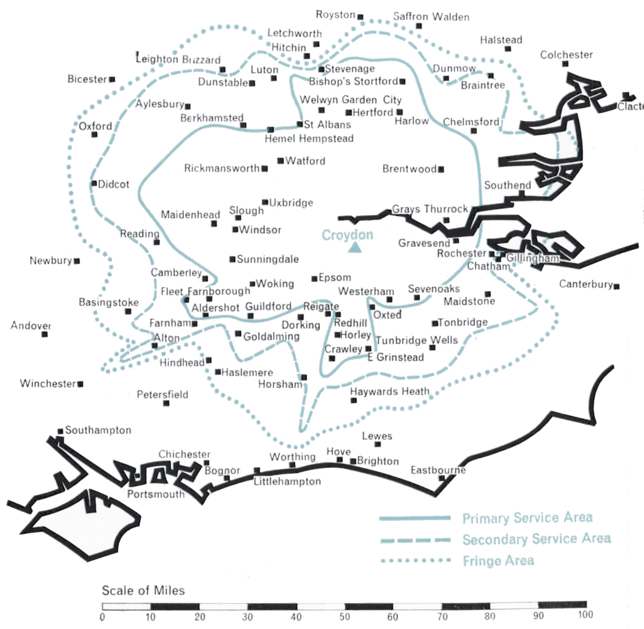
  • Population within predicted contours: Primary 10.52 mn, Secondary 1.72 mn, Fringe 0.67 mn. Total 12.91 mn.
  • Channel: Band III Channel 9 (vertically polarised)
  • Vision Carrier Frequency: Nominal 1974.75 Mc/s. Actual 194.75675 Mc/s
  • Sound Carrier Frequency: Nominal 191.25 Mc/s. Actual 191.266 Mc/s
  • Effective Radiated Power: Vision 400 kw. Sound 100 kw.
  • Power of Transmitters: Vision (peak white) 10 kW. Sound (carrier) 2½ kW
  • Heights above sea level: Site 375 ft. Mean aerial 825 ft.
  • Location: 0° 5′ 15″ W, 51° 24′ 35″ N.

Croydon (Channel 9)

Companies: Associated Rediffusion (weekdays), Associated TeleVision (weekends)

For the technical planner concerned with achieving national television coverage as economically as possible, London is the obvious point of departure. Within a radius of some forty miles from its heart live some twelve million people, almost one quarter of the total population of the United Kingdom. Topographically the London area presents no serious problem of propagation. It is relatively flat except for the North Downs some twenty-five miles to the south and the ridge of the Chiltern Hills some thirty miles to the west and north. Indeed, the difficulty is to find high ground close enough to the centre of London on which to construct a station. The choice rests between the 400 ft. ridges of Muswell Hill (Alexandra Palace) in North London and Sydenham (Crystal Palace) in South-East London.

Alexandra Palace was the BBC’s choice for their original Band I London station in 1935. Twenty years later, however, they were to move to a new station at Crystal Palace. In the interests of good planning the ITA decided to locate its first Band III station near this site, just a mile away on West Norwood Hill.

A suitable open space was found here for the construction of a small compact station which could be brought into operation with the least delay. The single 10 kW transmitter, the first Band III set constructed in this country, was a laboratory prototype and the aerial an experimental 8-stack omnidirectional vertically polarised array supported on a 200 ft. tower of virtually “stock” design. From this station on 22nd September 1955 the first programmes of Independent Television were transmitted. The effective radiated power was 60 kW (peak white vision), 15 kW (carrier sound). The potential population coverage was about 11 million people. After some months a second fully-engineered production 10 kW transmitter was installed as a standby. A little later, further equipment was installed to enable both sets of transmitters to be operated in parallel in order to double the station’s power.

It was realised that in due course the Croydon station must be given a higher tower and a new aerial system with directional characteristics tailored to give the optimum performance. Meanwhile, however, engineering effort was devoted to expanding the ITA network of stations to meet the fast-growing public demand for Independent Television programmes in other parts of the country. The completion of the BBC’s high tower at Crystal Palace allayed any fears that the mutual reflection of signals radiated from the two towers just a mile apart might be harmful to reception. Thus in February 1959 the Authority obtained Government approval to erect a higher tower and directional aerial at Croydon.

By the end of 1962 Croydon was transmitting from its slim new 500 ft. tower and radiating an effective power of about 400 kW directed to the north-west, with 5o to 100 kW e.r.p. in other directions, depending on the extent to which account had to be taken of the conflicting requirements of topography and co-channel interference with other ITA stations or with the television services of other countries. With its improved performance Croydon is bringing the programmes of Independent Television to a population of nearly 13 million in the London area, including some half a million viewers who have not before received any satisfactory ITV service.

Northern Ireland

Ulster

  • BLACK MOUNTAIN
  • Population within measured contours: Primary 1.03 mn, Secondary 0.10 mn, Fringe 0.07 mn. Total 1.20 mn.
  • Channel: Band III Channel 9 (horizontally polarised)
  • Vision Carrier Frequency: Nominal 194.75 Mc/s. Actual 194.74325 Mc/s
  • Sound Carrier Frequency: Nominal 191.25 Mc/s. Actual 191.234 Mc/s
  • Effective Radiated Power: Vision 100 kw maximum. Sound 25 kw maximum.
  • Power of Transmitters: Vision (peak white) 4 kW. Sound (carrier) 1 kW
  • Heights above sea level: Site 987 ft. Mean aerial 1,687 ft.
  • Location: 6° 1′ 10″ W, 54° 35′ 10″ N.
  • STRABANE
  • Population within predicted contours: Primary 0.108 mn, Secondary 0.073 mn, Fringe 0.069 mn. Total 0.25 mn.
  • Channel: Band III Channel 8 (vertically polarised)
  • Vision Carrier Frequency: Nominal 189.75 Mc/s. Actual 189.75675 Mc/s
  • Sound Carrier Frequency: Nominal 186.25 Mc/s. Actual 186.27 Mc/s
  • Effective Radiated Power: Vision 90 kw maximum. Sound 22.5 kw maximum.
  • Power of Transmitters: Vision (peak white) 2 x 2 kW. Sound (carrier) 2 x 0.5 kW
  • Heights above sea level: Site 900 ft. Mean aerial 1,875 ft.
  • Location: 7° 23′ 10″ W, 54° 48′ 0″ N.

Black Mountain (Channel 9) and Strabane (Channel 8)

Company: Ulster Television

A large part of Northern Ireland was provided with an Independent Television service in the Autumn of 1959 by the construction of the Black Mountain station near Belfast, close to the BBC’s existing Band I station at Divis. However, West Ulster, which includes the districts of Londonderry and Enniskillen, could not be covered by this station and, clearly, at least one additional station was needed.

The Black Mountain station overlooks Belfast and is 987 ft. above sea level. A 750 ft. mast, the highest permitted by the Ministry of Transport and Civil Aviation due to the proximity of the airport, was erected. It supports a moderately-directional aerial radiating about 100 kW to both the north-west and the south-west, 7o kW to the west and 20 kW to the east. This power-radiation pattern ensures the optimum coverage of the area whilst avoiding harmful interference to the service areas of other stations using Channel 9, notably Winter Hill.

Black Mountain
Black Mountain

A study of the topography of West Ulster revealed that the unserved area could economically be covered by a single station if a high site near Strabane could be obtained. A site 900 ft. above sea level was found four miles south-east of Strabane and here a station using a 1,000 ft. mast was constructed.

It has a highly-directional aerial radiating about 9o kW in two main lobes to the north and to the south. 10 kW only is radiated to the east and west, but this suffices to cover the areas not served by the Black Mountain transmitter and, at the same time, prevents unnecessary radiation into the territory of the Irish Republic to the west.

The Black Mountain station went into service on 31st October 1959. Strabane began programme transmission during February 1963.

South-West England

Westward

  • CARADON HILL
  • Population within measured contours: Primary 0.518 mn, Secondary 0.159 mn, Fringe 0.053 mn. Total 0.73 mn.
  • Channel: Band III Channel 12 (vertically polarised)
  • Vision Carrier Frequency: Nominal 209.75 Mc/s. Actual 209.74325 Mc/s
  • Sound Carrier Frequency: Nominal 206.25 Mc/s. Actual 206.23 Mc/s
  • Effective Radiated Power: Vision 200 kw maximum. Sound 50 kw maximum.
  • Power of Transmitters: Vision (peak white) 2 x 5 kW. Sound (carrier) 2 x 1.25 kW
  • Heights above sea level: Site 1,215 ft. Mean aerial 1,925 ft.
  • Location: 4° 26′ 8″ W, 50° 30′ 39″ N.
  • STOCKLAND HILL
  • Population within measured contours: Primary 0.362 mn, Secondary 0.405 mn, Fringe 0.148 mn. Total 0.915 mn.
  • Channel: Band III Channel 9 (vertically polarised)
  • Vision Carrier Frequency: Nominal 194.75 Mc/s. Actual 194.74325 Mc/s
  • Sound Carrier Frequency: Nominal 191.25 Mc/s. Actual 191.234 Mc/s
  • Effective Radiated Power: Vision 100 kw maximum. Sound 25 kw maximum.
  • Power of Transmitters: Vision (peak white) 2 x 5 kW. Sound (carrier) 2 x 1.25 kW
  • Heights above sea level: Site 750 ft. Mean aerial 1,460 ft.
  • Location: 3° 6′ 13″ W, 50° 48′ 23″ N.

Stockland Hill (Channel 9) and Caradon Hill (Channel 12)

Company: Westward Television

Propagation studies of the best method of covering the 150 mile long wedge-shaped area of Devon and Cornwall showed that it was not practical to serve it adequately from a single Band III station centrally situated on the heights of Dartmoor, adjacent to the BBC’s station at North Hessary Tor. Government agreement was obtained to build two stations, one in Cornwall and one in South Devon, another necessary departure from the principal of co-siting with the BBC Band I station.

High sites were found at Caradon Hill, near Launceston, for Cornwall; and at Stockland Hill, near Axminster, for Devon. Transmitting aerials with highly-directional lobes were engineered to give the desired grade of service to both areas while minimising interference with other ITA and Continental stations which use the same channels. Each station needed a 750 ft. mast to minimise “shadows” in this hilly terrain.

Stockland Hill
Stockland Hill

For Caradon Hill, the requirement was to give a service to the whole of Cornwall west of Dartmoor and reaching to the extremity of England at Land’s End. A power of 200 kW e.r.p. was beamed in this direction but to avoid interference in the service area of the Dublin station the power over an arc of 40° to the north-west had to be restricted to a mere 10 kW, while to the south the power had to be restricted to 25 kW to avoid interference in the service area of the Cherbourg station.

Studies showed that in order to cover Devon while not overlapping unnecessarily with the existing service area of St. Hilary, Stockland Hill should direct its maximum power in two lobes, one north-west towards Barnstaple and the other south-west towards Dartmouth. 100 kW was the maximum permissable radiated power but restriction to 10 kW eastwards was necessary to prevent interference in the London area, which also uses Channel 9. The shape of the aerial radiation pattern thus became that of a boomerang facing westwards

A subsidiary beam of about 5o kW directed south-east towards the island of Alderney was also desirable to ensure reliable reception of the Stockland Hill signal in the island, in order to relay the mainland programmes by Post Office microwave link to the Fremont Point station in Jersey for rebroadcasting in the Channel Islands. However, the service area of the existing French station at Bourges had to be protected and the power radiated towards Alderney was restricted to 20 kW. Fortunately, in practice, this power is just sufficient for the Stockland Hill signal to be received in Alderney, with a signal to noise ratio good enough for rebroadcasting from the Fremont Point station. Both stations went into service on 29th April 1961.

North-East Scotland

Grampian

  • DURRIS
  • Population within measured contours: Primary 0.403 mn, Secondary 0.566 mn, Fringe 0.304 mn. Total 1.273 mn.
  • Channel: Band III Channel 9 (horizontally polarised)
  • Vision Carrier Frequency: Nominal 194.75 Mc/s. Actual 194.75675 Mc/s
  • Sound Carrier Frequency: Nominal 191.25 Mc/s. Actual 191.266 Mc/s
  • Effective Radiated Power: Vision 400 kw maximum. Sound 100 kw maximum.
  • Power of Transmitters: Vision (peak white) 2 x 4 kW. Sound (carrier) 2 x 1 kW
  • Heights above sea level: Site 1,050 ft. Mean aerial 2,000 ft.
  • Location: 2° 23′ 22″ W, 57° 0′ 0″ N.
  • MOUNTEAGLE
  • Population within measured contours: Primary 0.096 mn, Secondary 0.042 mn, Fringe 0.005 mn. Total 0.143 mn.
  • Channel: Band III Channel 12 (horizontally polarised)
  • Vision Carrier Frequency: Actual 209.75 Mc/s
  • Sound Carrier Frequency: Actual 206.25 Mc/s
  • Effective Radiated Power: Vision 50 kw maximum. Sound 12.5 kw maximum.
  • Power of Transmitters: Vision (peak white) 2 kW. Sound (carrier) 0.5 kW
  • Heights above sea level: Site 730 ft. Mean aerial 1,480 ft.
  • Location: 4° 16′ 33″ W, 57° 53′ 33″ N.

Durris (Channel 9) and Mounteagle (Channel 12)

Company: Grampian Television

Two stations were necessary to cover North-East Scotland, one of medium power to serve the Inverness area and another of high power to cover Aberdeenshire and as much of Angus as possible. The main problem was to find the best site for the high-power station, which was not necessarily that of the existing BBC Band I station at Meldrum, north-west of Aberdeen.

Mounteagle
Mounteagle

For the Inverness area, a site was found at Mounteagle 730 ft. above sea level, on the Black Isle, about eight miles north of Inverness and close to the Band I station at Rosemarkie. An 800 ft. mast was used, and the maximum power of 5o kW was radiated in two directions, slightly east of north and east of south respectively. 35 kW is radiated in the direction of Lossiemouth eastwards along the Morayshire coast. Only 10 kW is radiated to the west, over the uninhabited mountainous areas of Ross and Cromarty.

Choosing the site for the high-power station to serve Aberdeen/Angus was more difficult because it was decided to try to cover the whole coastal area from Peterhead on the Moray Firth in the north to Arbroath on the Firth of Tay in the south, a distance of some 100 miles, and to include those parts of Dundee which did not receive a satisfactory service from Black Hill. A site at Durris, 1,o5o ft. above sea level, exposed, difficult of access and some 15 miles South of Aberdeen was selected. A 1,ooo ft. mast was used. Once again this choice involved a departure from the principle of adjacent siting with existing Band I stations.

The Durris station beams its power in two main lobes, each of 400 kW, one directed to the north and the other to the south-west, towards Dundee. Both stations went into service on 30th September 1961, and together cover satisfactorily the large area they were planned to serve.

Channel Islands

Channel

  • Population within measured contours: Primary 0.0513 mn, Secondary 0.0449 mn, Fringe 0.0038 mn. Total 0.10 mn.
  • Channel: Band III Channel 9 (horizontally polarised)
  • Vision Carrier Frequency: Actual 194.75 Mc/s
  • Sound Carrier Frequency: Actual 191.25 Mc/s
  • Effective Radiated Power: Vision 10 kw maximum. Sound 2.5 kw maximum.
  • Power of Transmitters: Vision (peak white) 2 x 0.5 kW. Sound (carrier) 2 x 1.25 kW
  • Heights above sea level: Site 330 ft above sea level. Mean aerial 760 ft. above sea level
  • Location: 2° 7′ 52″ W, 49° 15′ 8″ N.

Fremont Point (Channel 9)

Company: Channel Television

The Channel Islands lie in a dispersed group well out in the English Channel and close to the French coast, off the Cherbourg Peninsula. The population is concentrated mainly in the two largest islands, Jersey and Guernsey, about 6o,ooo in the former and 4o,ooo in the latter. The largest town is St. Helier on Jersey. The distance between Jersey and the Authority’s nearest mainland transmitting station, Stockland Hill, is about 120 miles, virtually all across sea. The island nearest to Stockland Hill is Alderney, the path length in this case being about 8o miles.

Studies showed that the only Band III channel which could be used to cover the islands without causing harmful interference in the service areas of several French stations was Channel 9, horizontally polarised, and even with this channel it would be necessary to restrict the power radiated towards the French coast to about 1 kW. Accordingly it was necessary to site the transmitting station on the north coast of Jersey, where 1 kW was just enough to serve that island, and to beam a higher power, 10 kW, across the sea to Guernsey which lies 25 miles distant in the direction of the English mainland.

ill-fremont pointThe supply of mainland programmes to the Jersey station for rebroadcasting in the islands presented unusual problems because, of necessity, both Stockland Hill and Fremont Point had to use Channel 9. The solution was to install on the small island of Alderney an “off the air” receiving station using diversity reception techniques, to pick up the Channel 9, vertically polarised, transmission from Stockland Hill 8o miles away and pass it over a multichannel microwave link to Fremont Point. The overseas path length of the microwave circuit is about 4o miles. To ensure that the Stockland Hill signal could be received in Alderney without interference from Fremont Point, the power radiated by Fremont Point towards Alderney on the same channel had to be restricted to the low value of 200 watts. This means that the people of Alderney are unable to receive the local programmes transmitted by Fremont Point, but fortunately many of them are able, with good aerials and receivers, to view directly if somewhat inconsistently the transmissions from Chillerton Down on Channel 11.

There are many complications in this apparently simple vision link scheme. The distances are such that the changing propagation conditions over the sea paths involved will cause wide fluctuations in the strength of the signals received in Alderney from Stockland Hill, and for a small proportion of the time these signals may be unusable for rebroadcasting from Fremont Point. The programme service began on 1st September 1962.