South and South-East England

Southern

  • CHILLERTON DOWN
  • Population within measured contours: Primary 1.91 mn, Secondary 0.53 mn, Fringe 0.52 mn. Total 2.96 mn.
  • Channel: Band III Channel 11 (vertically polarised)
  • Vision Carrier Frequency: Actual 204.75 Mc/s
  • Sound Carrier Frequency: Actual 201.25 Mc/s
  • Effective Radiated Power: Vision 100 kw maximum. Sound 25 kw maximum.
  • Power of Transmitters: Vision (peak white) 4 kW. Sound (carrier) 1 kW
  • Heights above sea level: Site 550 ft. Mean aerial 1,250 ft.
  • Location: 1° 19′ 40″ W, 50° 38′ 55″ N.
  • DOVER
  • Population within measured contours: Primary 0.50 mn, Secondary 0.57 mn, Fringe 0.27 mn. Total 1.34 mn.
  • Channel: Band III Channel 10 (vertically polarised)
  • Vision Carrier Frequency: Nominal 199.75 Mc/s. Actual 199.7135 Mc/s
  • Sound Carrier Frequency: Nominal 196.25 Mc/s. Actual 196.1985 Mc/s
  • Effective Radiated Power: Vision 100 kw maximum. Sound 25 kw maximum.
  • Power of Transmitters: Vision (peak white) 4 kW. Sound (carrier) 1 kW
  • Heights above sea level: Site 450 ft. Mean aerial 1,175 ft.
  • Location: 1° 14′ 58″ E, 51° 6′ 40″ N.

Chillerton Down (Channel 11) and Dover (Channel 10)

Company: Southern Television

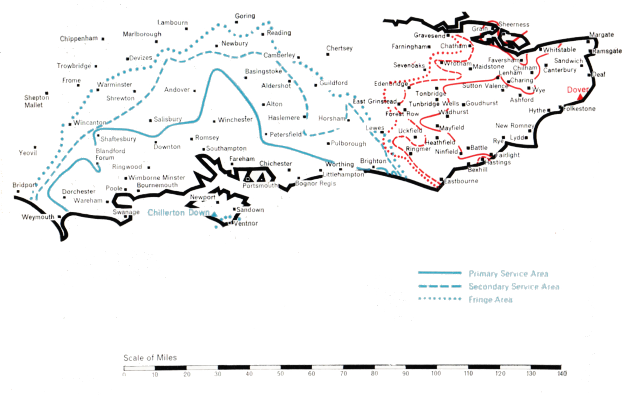
Chillerton Down was the first of the two stations built to serve the south and south-east coastal areas of Britain. It was designed to cover central southern England, the important agricultural and holiday area along the coast from Weymouth in the west to Brighton in the east, together with the great ports of Southampton and Portsmouth and, inland, the county of Hampshire and adjoining parts of Dorset and Wiltshire. A BBC Band I station existed at Rowridge, on the Isle of Wight. In conformity with the Government’s policy the Authority decided if possible to build its Band III station close to Rowridge. The site selected was on Chillerton Down, 550 ft. above sea level on the south side of the island. Opposition to a second television mast on the island was raised on grounds of amenity. However, the alternative of building at Rowridge a more massive and commanding tower to carry both the ITA and BBC television services and the BBC’s VHF sound services proved even less welcome, and the Authority’s proposal to use Chillerton Down for a slim 750 ft. mast was accepted.
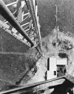
Chillerton Down
Chillerton Down

The transmitting aerial has a semicircular power-radiation pattern, oriented to direct 100 kW in both directions along the coast as well as landwards, but radiating very low power across the English Channel to prevent interference with the services of Radiodiffusion-Télévision Francaise. Chillerton Down went into service on 30th August 1958 and serves the intended area well.

The sister station at Dover presented unusual problems. The general requirement was to serve the south-east corner of England not covered by Chillerton Down or Croydon. The site of the station was determined by the need to serve Folkestone and Dover, which lie at sea level under high cliffs. The solution was to build the station on the high cliff road linking the two towns. Church Hougham, 450 feet above sea level, was used and from a 750 ft. mast a signal could be directed into both towns. At the same time the station had to link up with the service area of Chillerton Down beyond Eastbourne, 5o miles west along the coast. 100 kW was sufficient to provide an adequate service for Eastbourne and the intermediate coastal towns, and there were no inhibiting power restrictions. Northward, to serve the towns on the Thames estuary not covered by Croydon, 10 kW to 20 kW e.r.p. was adequate. However, viewers in France had to be protected from interference to their reception of the signal from the Rouen station. Calculations showed that Dover must restrict its power to less than 1 kW over an arc of 90° towards the French Coast. It was no mean task to construct a transmitting aerial to do this, and at the same time to radiate 100 kW westward. Test transmissions were made for many weeks, during which the Authority’s engineers developed a measuring technique, using a helicopter, to check the the radiation pattern of the transmitting aerial. This difficult operation accomplished, Dover went into service on full power on 31st January 1960.

The Borders

Border

  • CALDBECK
  • Population within measured contours: Primary 0.28 mn, Secondary 0.043 mn, Fringe 0.041 mn. Total 0.364 mn.
  • Channel: Band III Channel 11 (horizontally polarised)
  • Vision Carrier Frequency: Actual 204.75 Mc/s
  • Sound Carrier Frequency: Actual 201.25 Mc/s
  • Effective Radiated Power: Vision 100 kw maximum. Sound 25 kw maximum.
  • Power of Transmitters: Vision (peak white) 4 kW. Sound (carrier) 1 kW
  • Heights above sea level: Site 940 ft. Mean aerial 1,900 ft.
  • Location: 3° 5′ 21″ W, 54° 46′ 24″ N.
  • SELKIRK
  • Population within measured contours: Primary 0.071 mn, Secondary 0.026 mn, Fringe 0.019 mn. Total 0.116 mn.
  • Channel: Band III Channel 13 (vertically polarised)
  • Vision Carrier Frequency: Nominal 214.75 Mc/s. Actual 214.723 Mc/s
  • Sound Carrier Frequency: Nominal 211.25 Mc/s. Actual 211.223 Mc/s
  • Effective Radiated Power: Vision 25 kw maximum. Sound 6.25 kw maximum.
  • Power of Transmitters: Vision (peak white) 2 x 0.5 kW. Sound (carrier) 2 x 0.125 kW
  • Heights above sea level: Site 944 ft. Mean aerial 1,644 ft.
  • Location: 2° 47′ 30″ W, 55° 33′ 22″ N.

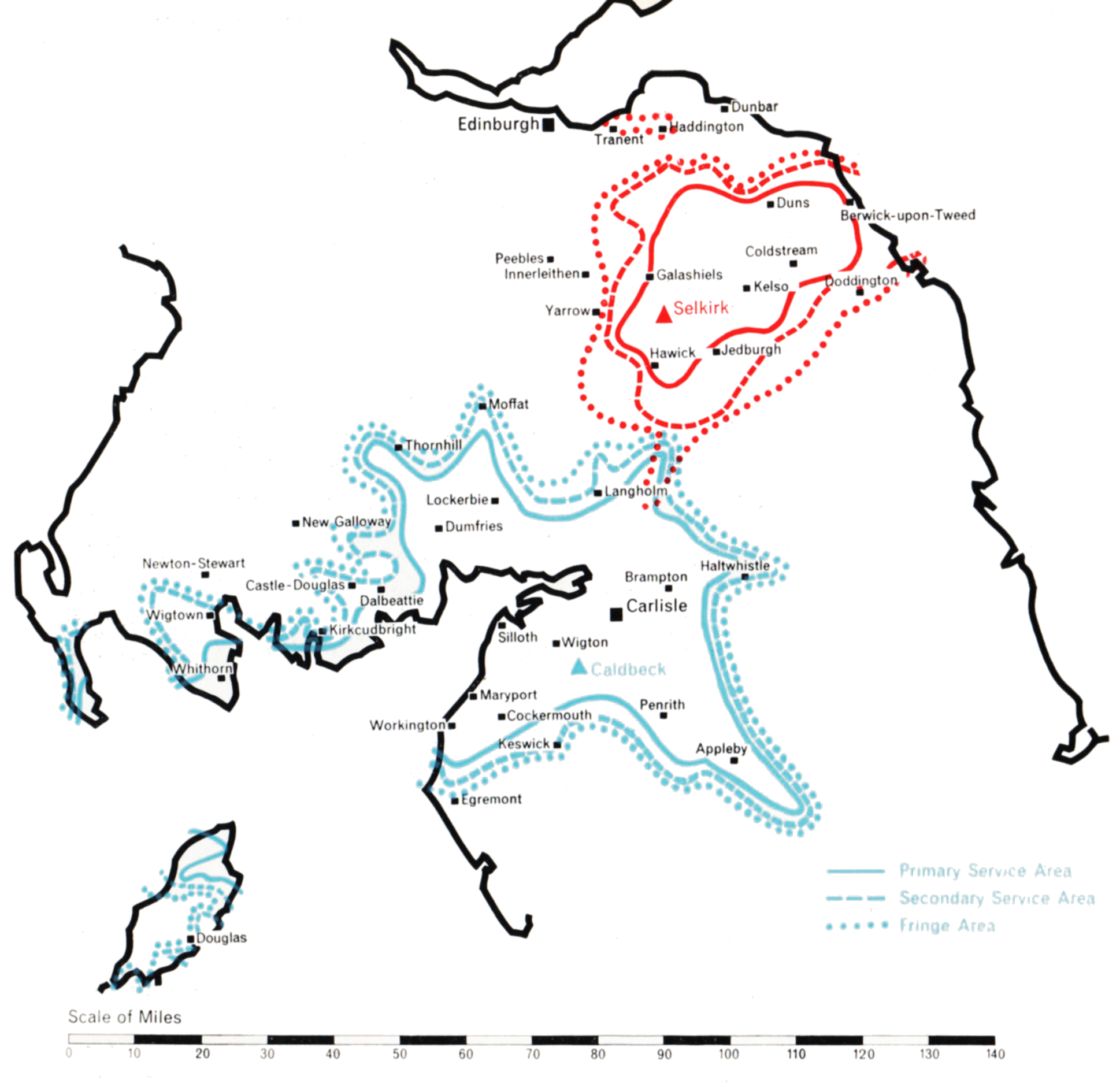
Calbeck (Channel 11) and Selkirk (Channel 13)

Company: Border Television

The Border country has two well-populated areas separated by the high sparsely-populated Cheviot Hills. That in the west extends north and south of the Solway Firth and includes the towns of Carlisle, Penrith and Dumfries. The other, in the east, embraces the Valley of the Tweed, and includes Selkirk and the coastal town of Berwick-on-Tweed.

Planning studies indicated that the best way of serving the pupulated areas was to build two separate stations, one near Carlisle and one near Selkirk. The site chosen for the first station was at Caldbeck, 940 ft. above sea level and some 10 miles west of Carlisle, in the foothills of the Cumbrian Mountains. Caldbeck lies somewhat to the south of the area to be served and a directional transmitting aerial supported on a 1,000 ft. mast was provided to radiate the maximum power of 100 kW to the northeast and the south-west, about 7o kW to the north-west across the Solway Firth, but only 20 kW to the south-east. In this direction the useful signal would naturally be blocked by mountainous country, which would not, however, prevent an interfering signal from penetrating into the service area of Mendlesham (which uses the same channel) some 200 miles distant, unless power in that direction were appropriately restricted.

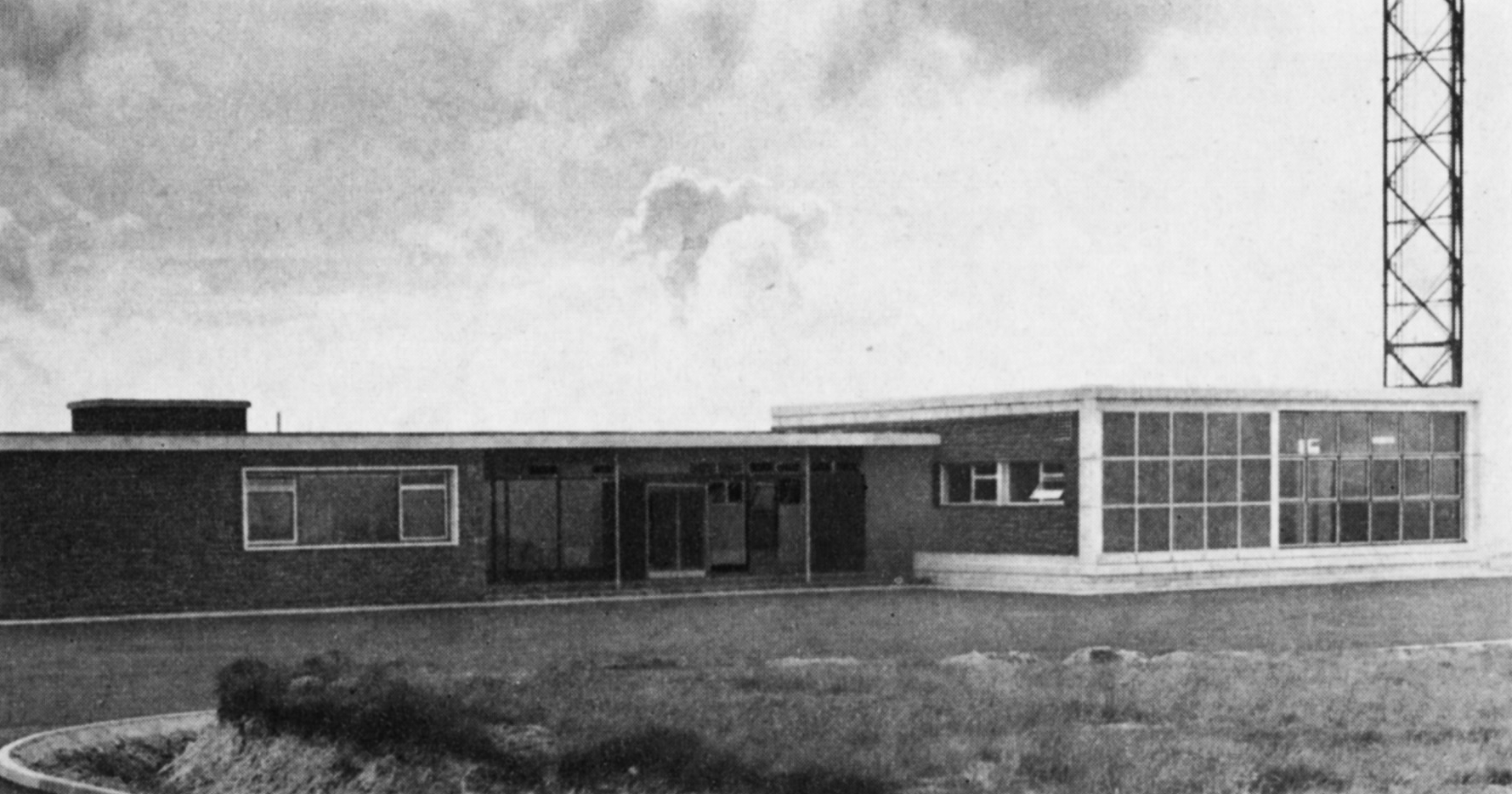
Caldbeck
Caldbeck

The second station was built on Lindean Moor, 944 feet above sea level and close to Selkirk. It has a 750 ft. mast and an aerial which radiates its effective power of 25 kW mainly eastwards towards the coast. This provides a good secondary service in Berwick-on-Tweed, whilst the numerous small towns of the Tweed Valley all receive a primary service.

The Selkirk station is a satellite of Caldbeck. It obtains its programmes by direct radio pick-up from Caldbeck and rebroadcasts them on a different channel. It is the first of a number of unattended remotely-controlled satellite stations of medium to low power to be constructed by the Authority.

Caldbeck began programme service on 1st September 1961 and Selkirk on 1st December in the same year, and both well fulfil the purpose for which they were designed.

West and North Wales

WWN

  • PRESELY
  • Population within measured contours: Primary 0.091 mn, Secondary 0.134 mn, Fringe 0.356 mn. Total 0.581 mn.
  • Channel: Band III Channel 8 (horizontally polarised)
  • Vision Carrier Frequency: Nominal 189.75 Mc/s. Actual 189.75675 Mc/s
  • Sound Carrier Frequency: Nominal 186.25 Mc/s. Actual 186.27 Mc/s
  • Effective Radiated Power: Vision 100 kw maximum. Sound 25 kw maximum.
  • Power of Transmitters: Vision (peak white) 5 kW. Sound (carrier) 1.25 kW
  • Heights above sea level: Site 1,100 ft. Mean aerial 1,835 ft.
  • Location: 4° 39′ 35″ W, 51° 56′ 30″ N.
  • ARFON
  • Population within measured contours: Primary 0.83 mn, Secondary 0.033 mn, Fringe 0.027 mn. Total 0.143 mn.
  • Channel: Band III Channel 10 (horizontally polarised)
  • Vision Carrier Frequency: Nominal 199.75 Mc/s. Actual 199.74725 Mc/s
  • Sound Carrier Frequency: Nominal 196.25 Mc/s. Actual 196.2605 Mc/s
  • Effective Radiated Power: Vision 10 kw maximum. Sound 2.5 kw maximum.
  • Power of Transmitters: Vision (peak white) 2 x 0.5 kW. Sound (carrier) 2 x 0.125 kW
  • Heights above sea level: Site 950 ft. Mean aerial 1,925 ft.
  • Location: 4° 16′ 10″ W, 53° 1′ 10″ N.
  • MOEL-Y-PARC
  • Population within measured contours: Primary 0.132 mn, Secondary 0.145 mn, Fringe 0.057 mn. Total 0.334 mn.
  • Channel: Band III Channel 11 (vertically polarised)
  • Vision Carrier Frequency: Nominal 204.75 Mc/s. Actual 204.75675 Mc/s
  • Sound Carrier Frequency: Nominal 201.25 Mc/s. Actual 201.27 Mc/s
  • Effective Radiated Power: Vision 25 kw maximum. Sound 6.25 kw maximum.
  • Power of Transmitters: Vision (peak white) 2 x 0.5 kW. Sound (carrier) 2 x 0.125 kW
  • Heights above sea level: Site 1,115 ft. Mean aerial 1,815 ft.
  • Location: 3° 18′ 48″ W, 53° 13′ 15″ N.

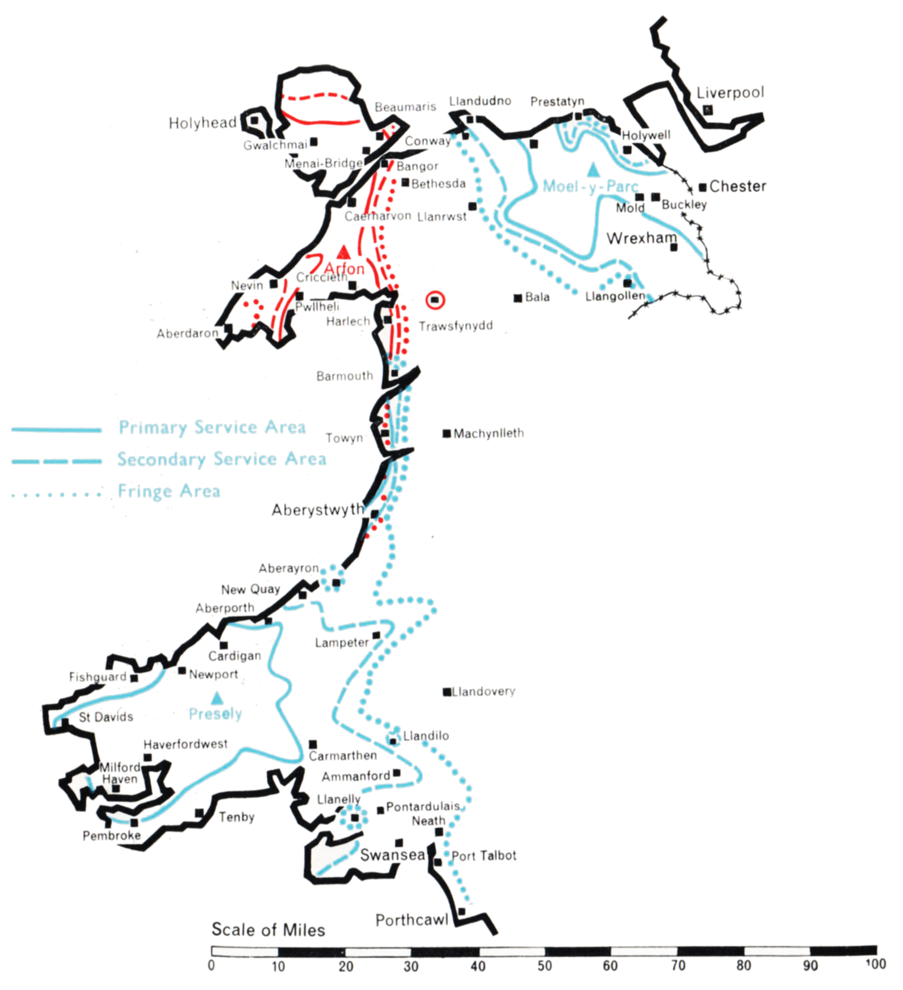
Presely (Channel 8), Arfon (Channel 10), and Moel-y-Parc (Channel 11)

Company: Wales (West and North) Television

This group of stations was planned to bring Independent Television programmes to the Welsh-speaking populations of West and North Wales, including the area bordering on Cheshire which contains the towns of Denbigh, Mold and Wrexham. The populated areas are mainly along the west coast from Pembroke to Anglesey, and on the north coast from Conway and Llandudno to Prestatyn.

The technical problem was unusually complicated. It has been solved by the establishment of three stations, one on the Prescelly mountains in Pembrokeshire, one on the Lleyn Peninsula, and one on the Clwydian Range of mountains in the Flint-Denbigh area. This plan departed considerably from an earlier one based on sites previously selected for BBC Band I stations.

ill-preselli
Presely

A site for the Presely station was found at Foel Drych 1,100 ft. above sea level, where a 770 ft. mast was sufficient to give the required coverage, although the radiation pattern of the transmitting aerial had to be extremely complicated. A narrow beam radiating 8o kW to the north was required to ensure a reliable programme link to the Arfon relay station. A beam of 100 kW to the south-east, in the direction of Carmarthen and Llanelly, was necessary to ensure that the service area of Presely joined that of St. Hilary; and a broad lobe of 5o kW to the south-west was needed to serve Pembrokeshire. At the same time severe power restrictions had to be incorporated in several directions to avoid co-channel interference in the service areas of the ITA’s transmitters at Strabane, Burnhope and Lichfield, the Kilkenny station of the Irish Republic, and the French stations serving the coast of Brittany. Intensive development was necessary to construct an aerial with this complicated radiation pattern.

The unattended Arfon station, which rebroadcasts the Presely transmissions, is at Bryn-ychain, ten miles south of Caernarvon, 950 ft. above sea level. A 1,ooo ft. mast was used to “see” over the mountains of Portmadoc to the coast of Cardigan Bay from Harlech to Barmouth, and to ensure the link with the service area of Presely. A directional aerial was again necessary. 10 kW is radiated to the north and south-west, 5 kW to the east and south-east, and 2.5 kW to the west.

The third station is at Moel-y-Parc, a peak in the Clwydian Range 1,100 ft. above sea level, and serves the North Wales area. A 750 ft. mast was found adequate to reach the coastal resins from Conway to Prestatyn, which are shielded by mountains close to the coast. The radiation pattern of the transmitting aerial is approximately semicircular, 25 kW being radiated from south-east to north-west with reduced power to the north and east. This was necessary to cover the Welsh areas but to avoid overlap with English areas already served by Winter Hill. Moel-y-Parc rebroadcasts the transmissions from the Arfon station, conveyed to it by an off the air pick-up at Nebo, in Anglesey, followed by a microwave link.

All three stations for the west and north of the Principality were in programme service by early 1963.

East Anglia

Anglia

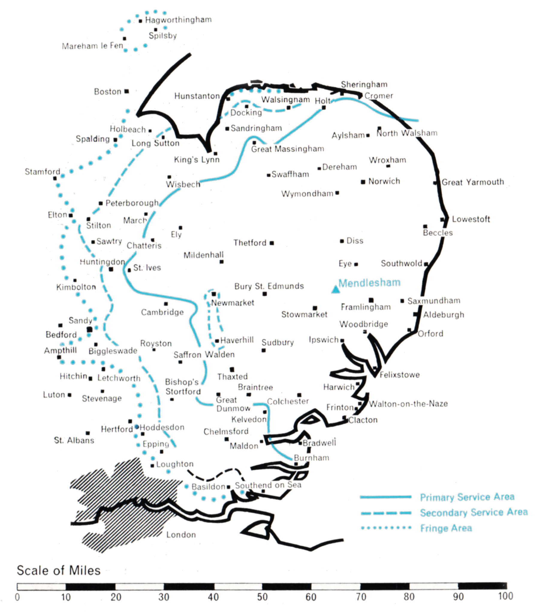
  • Population within measured contours: Primary 1.22 mn, Secondary 0.96 mn, Fringe 0.37 mn. Total 2.55 mn.
  • Channel: Band III Channel 11 (horizontally polarised)
  • Vision Carrier Frequency: Nominal 204.75 Mc/s. Actual 204.74325 Mc/s
  • Sound Carrier Frequency: Nominal 201.25 Mc/s. Actual 201.23 Mc/s
  • Effective Radiated Power: Vision 200 kw maximum. Sound 50 kw maximum.
  • Power of Transmitters: Vision (peak white) 2 x 5 kW. Sound (carrier) 2 x 1.25 kW
  • Heights above sea level: Site 200 ft. Mean aerial 1,150 ft.
  • Location: 1° 6′ 32″ E, 52° 14′ 3″ N.

Mendlesham (Channel 11)

Company: Anglia Television

The geographically large but not densely populated area of East Anglia which this station is designed to serve is of unusual interest to the technical planner. It is largely flat and circular in shape, with a diameter of about eighty miles. At first sight it seems to present an almost ideal case for service by an uncomplicated high-power station located at the geographical centre, radiating its power omnidirectionally. As so often happens, the simple approach could not be applied. The possibility of causing interference to West German viewers in the established service area of the Langenberg station and to French viewers of the Amiens station demanded that the power radiated over a prescribed south-easterly arc must not exceed about 15 kW. Other complications included the need to prevent interference in the service area of Chillerton Down, which uses the same channel, and the need to observe the principle that ITA and BBC stations should be adjacently sited.

ill-mendelsham

Thus, to secure adequate service to the coastal areas of Suffolk and Essex, the site for the station had to be displaced well to the south-east of the geographical centre of the required service area and, incidentally, far from the BBC Norwich Band I station which serves much of the same general area. The Television Advisory Committee confirmed the Authority’s conclusion that adjacent siting could not be followed in this instance and that the best site for the ITA station was at Mendlesham, about fifteen miles north-west of Ipswich. The towns of Ipswich, Colchester, Felixstowe and Harwich would then be close enough to the station to be well served, despite the relatively low power radiated in their direction.

To compensate for the displacement of the station from the natural geographical centre it was necessary for the power radiated towards the west and north to approach 200 kW. Again, because of the very low height of the Mendlesham site, 210 ft. above sea level, a 1,ooo ft. mast was considered technically appropriate. This was the highest television mast to be constructed in Europe and the first of five of the same height subsequently used at other ITA stations. The building of the station began early in 1959, and after some corrective adjustments to the aerial power-feeding networks the station began programme service on 27th October 1959.