Central Scotland

Scottish

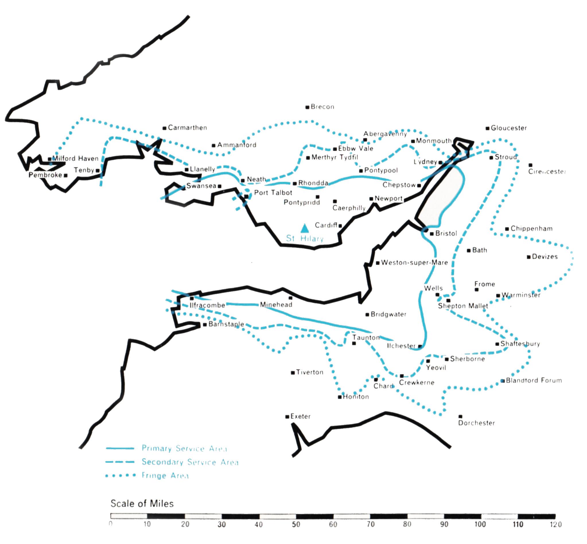
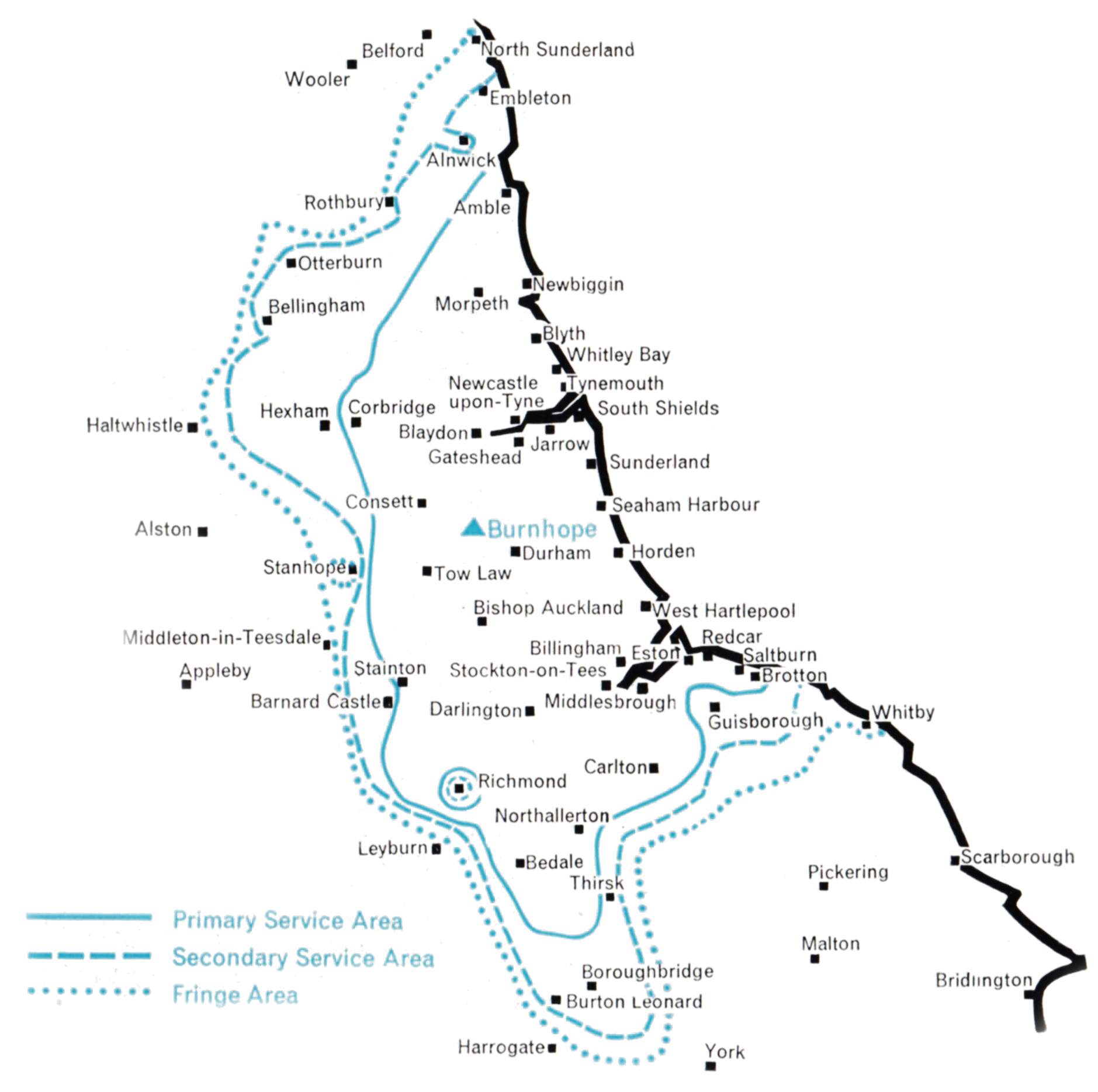
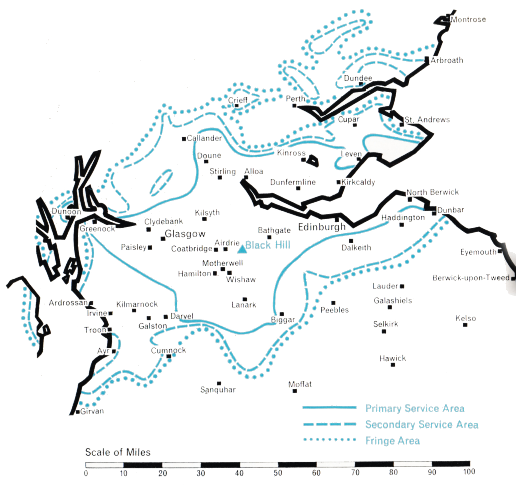
  • Population within measured contours: Primary 3.23 mn, Secondary 0.54 mn, Fringe 0.21 mn. Total 3.98 mn.
  • Channel: Band III Channel 10 (vertically polarised)
  • Vision Carrier Frequency: Nominal 199.75 Mc/s. Actual 199.7305 Mc/s
  • Sound Carrier Frequency: Nominal 196.25 Mc/s. Actual 196.2395 Mc/s
  • Effective Radiated Power: Vision 475 kw maximum. Sound 120 kw maximum.
  • Power of Transmitters: Vision (peak white) 2 x 10 kW. Sound (carrier) 2 x 2.5 kW
  • Heights above sea level: Site 900 ft. Mean aerial 1,850 ft.
  • Location: 3° 52′ 25″ W, 55° 51′ 45″ N.

Black Hill (Channel 10)

Company: Scottish Television

The construction of this station, on a site 900 ft. above sea level and midway between Glasgow and Edinburgh, began in the late summer of 1956. The station was designed to serve the central lowlands of Scotland, covering a population of nearly four millions within the o.25 mV/m contour.

The selection of the site was straightforward, but there was difficulty in obtaining the land.

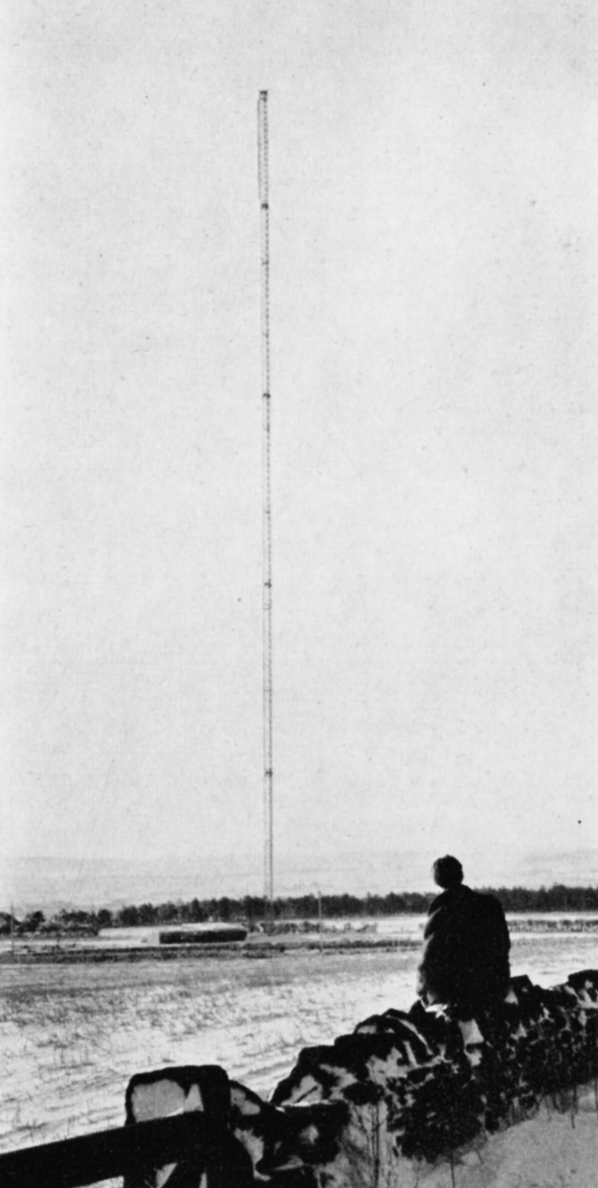
A study of the topography within the required service area of this station established the need for a 750 ft. mast and it was evident that the best possible coverage could be obtained only by using a directional aerial system. It was important that, if possible, both Dundee in the north-east and the towns on the Ayrshire coast in the west should be included in the service area. Little benefit, however, would result from radiating high power into the hilly north-westerly or south-easterly directions. It thus appeared that an aerial having an elliptical power distribution pattern with its major axis aligned to the north-east and south-west would provide the best result. However, an international limitation on power in certain directions made it necessary to compromise and to design an aerial whose radiation pattern can best be described as “boot”-shaped, the “heel” (250 kw) directed towards the south-west and the “sole” (475 kW) directed to the north-east. A power of about 150 kW was adequate for the northwest and south-west directions.

ill-black hill
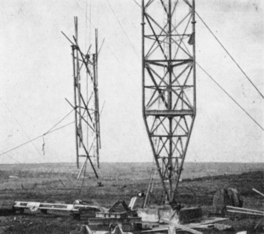
A novel 16-stack vertically-polarised directional aerial system was developed, possessing many useful features, which attempted to approximate to the optimum power-radiation pattern. The aerial was located centrally within the mast structure to radiate through the opening of the lattice steel formation of the mast, mainly to reduce the wind loading and icing on the exposed site.

Unfortunately, complex anomalies in the behaviour of this aerial caused its performance to deviate from the prediction. The desired power in the various directions was not completely achieved, while the radiation in the south-west sector in the direction of Ayr was predominantly horizontally instead of vertically polarised. The result was a marginal shift in the potential service area of the station. These anomalies had to be accepted for the time being, and the station came into service on 31st August 1957.

In 1959 it was decided to replace the “inside the mast” aerial by one of more conventional form, with the radiators mounted outside the mast. In order to ensure continuity of service, it was also decided to erect the replacement aerial on a new 1,ooo ft. mast near the original mast.

The difficult task of constructing the new mast close to the old began in August 1960. It was brought into use together with the new aerial on 10th July 1961. The 750 ft. mast was dismantled and has been used at the Selkirk station in the Borders. The performance of the new aerial at Black Hill is satisfactory and has resulted in an enlargement of the service area and in improvements to reception generally.

South Wales and West of England

TWW

  • Population within measured contours: Primary 1.517 mn, Secondary 1.0 mn, Fringe 0.77 mn. Total 3.287 mn.
  • Channel: Band III Channel 10 (vertically polarised)
  • Vision Carrier Frequency: Nominal 199.75 Mc/s. Actual 199.7305 Mc/s
  • Sound Carrier Frequency: Nominal 196.25 Mc/s. Actual 196.2395 Mc/s
  • Effective Radiated Power: Vision 200 kw maximum. Sound 50 kw maximum.
  • Power of Transmitters: Vision (peak white) 20 kW. Sound (carrier) 5 kW
  • Heights above sea level: Site 400 ft. Mean aerial 1,100 ft.
  • Location: 3° 24′ 15″ W, 51° 27′ 25″ N.

St. Hilary (Channel 10)

Company: T.W.W.

This station brings the Independent Television programmes to the Welsh and English populations adjacent to the Severn Estuary and the Bristol Channel. With the limited number of Band III channels available to the Authority, each one had to be used to serve the maximum possible geographical area. In May 1955, studies were begun to determine which of a number of approaches to the problem of covering South Wales, North Somerset and North Devon was the best. The coverage potential of sites to the south of the Estuary in the Mendips and the Quantocks, as well as on the north shore in various parts of South Wales, was investigated.

A site was selected at St. Hilary Down, on the Welsh side of the estuary, between Cardiff and Swansea, and 400 ft. above sea level. This gave the maximum potential population coverage of the densely populated areas of industrial South Wales and Monmouthshire, and was adjacent to the BBC Band I station at Wenvoe a few miles to the east, serving broadly the same geographical area.

ill-st hilaryThe mast height at St. Hilary is 750 ft. The Authority would have preferred 1,000 ft., but air navigation considerations precluded this. Even so, approval for the site had to be withheld by the Glamorgan County Council pending a public enquiry, held in March 1957, to resolve the objections to the mast lodged by the airline companies operating from the nearby Rhoose Airport. The effective radiated power is 200 kW omni-directional, because directional characteristics would have been of little avail in improving the service for the many valleys of South Wales, which radiate northwards like spokes of a wheel from the “hubs” of Cardiff and Newport.

A major redesign of the aerial system had to be undertaken, because the intended “inside the mast” type of aerial, the prototype of which had just been tested at the Black Hill station in Scotland, had been found to be deficient.

The station was opened for programmes, with an aerial of more conventional design, on 14th January 1958. It has given the high grade of service predicted, but the fundamental limitations of Band III transmission and reception in mountainous terrain when compared with Band I led to some public disappointment about the comparative grades of service in some shielded locations in the deep valleys of South Wales and also in low-lying parts of the cities of Bristol and Bath. The use of well designed receiving aerials and of more sensitive “fringe area” receivers has overcome, in part, the low signal strength and the “ghost” images experienced in such localities.

North-East England

TTT

  • Population within measured contours: Primary 2.48 mn, Secondary 0.19 mn, Fringe 0.05 mn. Total 2.72 mn.
  • Channel: Band III Channel 8 (horizontally polarised)
  • Vision Carrier Frequency: Nominal 189.75 Mc/s. Actual 189.75675 Mc/s
  • Sound Carrier Frequency: Nominal 186.25 Mc/s. Actual 186.27 Mc/s
  • Effective Radiated Power: Vision 100 kw maximum. Sound 25 kw maximum.
  • Power of Transmitters: Vision (peak white) 4 kW. Sound (carrier) 1 kW
  • Heights above sea level: Site 800 ft. Mean aerial 1,500 ft.
  • Location: 1° 42′ 50″ W, 54° 49′ 25″ N.

Burnhope (Channel 8)

Company: Tyne Tees Television

The important highly-populated industrial and agricultural area of North-East England, between the eastern slopes of the Pennine Chain and the sea, lies beyond the range of the Emley Moor transmitter in Yorkshire. Another station was therefore needed to provide an Independent Television service for this area.

ill-burnhopeA high site was found at Burnhope, about ten miles south-west of Newcastle-upon-Tyne, the major city in the area. It was within a few miles of the existing Band I station at Pontop Pike. Finding a site presented no special difficulty except the importance of avoiding land liable to mining subsidence, which abounds in this locality. This was responsible for some delay while the records were searched and test bores made.

A mast 750 feet in height was needed to prevent “shadowing” in the rather hilly country and the maximum power of 100 kW which could be permitted on this channel was radiated in both the northerly and the southerly directions, so as to extend the service as far as possible. To the west the service is naturally blocked by the high barrier of the Pennine Chain and to the east its usefulness is limited by the North Sea. The power radiated in these directions was therefore limited to 20 kW and 7o kW respectively, no higher power being necessary. Again a special aerial had to be developed to give the required directional effect.

The station went into programme service on 15th January 1959 and has fulfilled its predicted performance.

East Anglia

Anglia

  • Population within measured contours: Primary 1.22 mn, Secondary 0.96 mn, Fringe 0.37 mn. Total 2.55 mn.
  • Channel: Band III Channel 11 (horizontally polarised)
  • Vision Carrier Frequency: Nominal 204.75 Mc/s. Actual 204.74325 Mc/s
  • Sound Carrier Frequency: Nominal 201.25 Mc/s. Actual 201.23 Mc/s
  • Effective Radiated Power: Vision 200 kw maximum. Sound 50 kw maximum.
  • Power of Transmitters: Vision (peak white) 2 x 5 kW. Sound (carrier) 2 x 1.25 kW
  • Heights above sea level: Site 200 ft. Mean aerial 1,150 ft.
  • Location: 1° 6′ 32″ E, 52° 14′ 3″ N.

Mendlesham (Channel 11)

Company: Anglia Television

The geographically large but not densely populated area of East Anglia which this station is designed to serve is of unusual interest to the technical planner. It is largely flat and circular in shape, with a diameter of about eighty miles. At first sight it seems to present an almost ideal case for service by an uncomplicated high-power station located at the geographical centre, radiating its power omnidirectionally. As so often happens, the simple approach could not be applied. The possibility of causing interference to West German viewers in the established service area of the Langenberg station and to French viewers of the Amiens station demanded that the power radiated over a prescribed south-easterly arc must not exceed about 15 kW. Other complications included the need to prevent interference in the service area of Chillerton Down, which uses the same channel, and the need to observe the principle that ITA and BBC stations should be adjacently sited.

ill-mendelsham

Thus, to secure adequate service to the coastal areas of Suffolk and Essex, the site for the station had to be displaced well to the south-east of the geographical centre of the required service area and, incidentally, far from the BBC Norwich Band I station which serves much of the same general area. The Television Advisory Committee confirmed the Authority’s conclusion that adjacent siting could not be followed in this instance and that the best site for the ITA station was at Mendlesham, about fifteen miles north-west of Ipswich. The towns of Ipswich, Colchester, Felixstowe and Harwich would then be close enough to the station to be well served, despite the relatively low power radiated in their direction.

To compensate for the displacement of the station from the natural geographical centre it was necessary for the power radiated towards the west and north to approach 200 kW. Again, because of the very low height of the Mendlesham site, 210 ft. above sea level, a 1,ooo ft. mast was considered technically appropriate. This was the highest television mast to be constructed in Europe and the first of five of the same height subsequently used at other ITA stations. The building of the station began early in 1959, and after some corrective adjustments to the aerial power-feeding networks the station began programme service on 27th October 1959.

Channel Islands

Channel

  • Population within measured contours: Primary 0.0513 mn, Secondary 0.0449 mn, Fringe 0.0038 mn. Total 0.10 mn.
  • Channel: Band III Channel 9 (horizontally polarised)
  • Vision Carrier Frequency: Actual 194.75 Mc/s
  • Sound Carrier Frequency: Actual 191.25 Mc/s
  • Effective Radiated Power: Vision 10 kw maximum. Sound 2.5 kw maximum.
  • Power of Transmitters: Vision (peak white) 2 x 0.5 kW. Sound (carrier) 2 x 1.25 kW
  • Heights above sea level: Site 330 ft above sea level. Mean aerial 760 ft. above sea level
  • Location: 2° 7′ 52″ W, 49° 15′ 8″ N.

Fremont Point (Channel 9)

Company: Channel Television

The Channel Islands lie in a dispersed group well out in the English Channel and close to the French coast, off the Cherbourg Peninsula. The population is concentrated mainly in the two largest islands, Jersey and Guernsey, about 6o,ooo in the former and 4o,ooo in the latter. The largest town is St. Helier on Jersey. The distance between Jersey and the Authority’s nearest mainland transmitting station, Stockland Hill, is about 120 miles, virtually all across sea. The island nearest to Stockland Hill is Alderney, the path length in this case being about 8o miles.

Studies showed that the only Band III channel which could be used to cover the islands without causing harmful interference in the service areas of several French stations was Channel 9, horizontally polarised, and even with this channel it would be necessary to restrict the power radiated towards the French coast to about 1 kW. Accordingly it was necessary to site the transmitting station on the north coast of Jersey, where 1 kW was just enough to serve that island, and to beam a higher power, 10 kW, across the sea to Guernsey which lies 25 miles distant in the direction of the English mainland.

ill-fremont pointThe supply of mainland programmes to the Jersey station for rebroadcasting in the islands presented unusual problems because, of necessity, both Stockland Hill and Fremont Point had to use Channel 9. The solution was to install on the small island of Alderney an “off the air” receiving station using diversity reception techniques, to pick up the Channel 9, vertically polarised, transmission from Stockland Hill 8o miles away and pass it over a multichannel microwave link to Fremont Point. The overseas path length of the microwave circuit is about 4o miles. To ensure that the Stockland Hill signal could be received in Alderney without interference from Fremont Point, the power radiated by Fremont Point towards Alderney on the same channel had to be restricted to the low value of 200 watts. This means that the people of Alderney are unable to receive the local programmes transmitted by Fremont Point, but fortunately many of them are able, with good aerials and receivers, to view directly if somewhat inconsistently the transmissions from Chillerton Down on Channel 11.

There are many complications in this apparently simple vision link scheme. The distances are such that the changing propagation conditions over the sea paths involved will cause wide fluctuations in the strength of the signals received in Alderney from Stockland Hill, and for a small proportion of the time these signals may be unusable for rebroadcasting from Fremont Point. The programme service began on 1st September 1962.